Wierzbno geodata
Wierzbno (Lower Silesia) is a populated place; located in Poland in Europe/Warsaw (GMT+2) time zone. With population of 1,047 people, there are 2408 cities with bigger population in this country. Compared to other cities in Poland, 56.7% of cities are located further ↑North; 82.3% of cities are located further →East and 62.7% of cities have higher elevation than Wierzbno. Note1


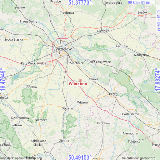
Wierzbno GPS coordinates[2]
50° 56' 12.264" North, 17° 10' 46.596" East
| Map corner | latitude | longitude |
|---|---|---|
| Upper-left | 51.37773°, | 16.47649° |
| Center: | 50.93674°, | 17.17961° |
| Lower-right: | 50.49153°, | 17.88274° |
| Map W x H: | 98.5×98.5 km | = 61.2×61.2mi |
| max Lat: | 54.83135° ⇑56.7% North |
| Wierzbno: | 50.93674° |
| min Lat: | ⇓43.3% South 49.21328° |
| min Long | Wierzbno | max Long |
| 14.20249° | 17.17961° | 24.03723° |
| W 17.7%⇐ | ⇒82.3% E |
Elevation
Elevation of Wierzbno is 140 m = 459 ft, and this is 51.4 m = 169 ft below average elevation for this country.
| Max E: |
974 m = 3196 ft | 62.7% |
| Avg. | 191.4 m = 628 ft | |
| Wierzbno | 140 m = 459 ft | |
Min E: |
-3 m = -10 ft | 37.3% |
See also: Poland elevation on elevation.city.
Geographical zone
Wierzbno is located in North temperate zone (between Tropic of Cancer and the Arctic Circle). Distance of this North polar circle is 1737.5 km =1079.6 mi to North.| Distance of | km | miles | from Wierzbno |
|---|---|---|---|
| North Pole | 4343.4 | 2698.9 | to North |
| Arctic Circle | 1737.5 | 1079.6 | to North |
| Tropic Cancer | 3057.7 | 1900 | to South |
| Equator | 5663.6 | 3519.2 | to South |


Nearby cities:
15 places around Wierzbno: (largest is in red/bold)
• Czernica
13 km =8.1 mi,  20°
20°
• Domaniów
5.9 km =3.7 mi,  216°
216°
• Gajków
13.7 km =8.5 mi,  2°
2°
• Jelcz
13.6 km =8.5 mi,  46°
46°
• Jelcz Laskowice
13.4 km =8.3 mi, 45°
• Osiek
9.6 km =6 mi,  124°
124°
• Oława
8 km =5 mi,  82°
82°
• Radwanice
13.9 km =8.6 mi,  339°
339°
• Ratowice
12.5 km =7.8 mi,  31°
31°
• Siechnice
11 km =6.8 mi,  348°
348°
• Wiązów
13.7 km =8.5 mi,  173°
173°
• Węgry
9.9 km =6.2 mi,  264°
264°
• Święta Katarzyna
10.9 km =6.8 mi, 335°
• Żerniki Wrocławskie
13.7 km =8.5 mi,  321°
321°
• Żórawina
11.1 km =6.9 mi,  296°
296°
Sources, notices
• [Note1] Compared only with cities in Poland existing in our database
• [Src1] Map data: © OpenStreetMap contributors (CC-BY-SA)
• [Src2] Other city data from geonames.org with taken over terms of usage.
• [Src3] Geographical zone / Annual Mean Temperature by Robert A. Rohde @ Wikipedia
