Chociwel geodata
Chociwel (West Pomerania) is a seat of a third-order administrative division; located in Poland in Europe/Warsaw (GMT+2) time zone. With population of 3,266 people, there are 974 cities with bigger population in this country. Compared to other cities in Poland, 89.2% of cities are located further ↓South; 96.3% of cities are located further →East and 90.6% of cities have higher elevation than Chociwel. Note1


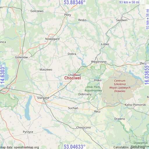
Chociwel GPS coordinates[2]
53° 28' 1.056" North, 15° 20' 0.312" East
| Map corner | latitude | longitude |
|---|---|---|
| Upper-left | 53.88346°, | 14.6303° |
| Center: | 53.46696°, | 15.33342° |
| Lower-right: | 53.04633°, | 16.03655° |
| Map W x H: | 93.1×93.1 km | = 57.8×57.8mi |
| max Lat: | 54.83135° ⇑10.8% North |
| Chociwel: | 53.46696° |
| min Lat: | ⇓89.2% South 49.21328° |
| min Long | Chociwel | max Long |
| 14.20249° | 15.33342° | 24.03723° |
| W 3.7%⇐ | ⇒96.3% E |
Elevation
Elevation of Chociwel is 72 m = 236 ft, and this is 119.4 m = 392 ft below average elevation for this country.
| Max E: |
974 m = 3196 ft | 90.6% |
| Avg. | 191.4 m = 628 ft | |
| Chociwel | 72 m = 236 ft | |
Min E: |
-3 m = -10 ft | 9.4% |
See also: Poland elevation on elevation.city.
Geographical zone
Chociwel is located in North temperate zone (between Tropic of Cancer and the Arctic Circle). Distance of this North polar circle is 1456.2 km =904.8 mi to North.| Distance of | km | miles | from Chociwel |
|---|---|---|---|
| North Pole | 4062.1 | 2524.1 | to North |
| Arctic Circle | 1456.2 | 904.8 | to North |
| Tropic Cancer | 3339 | 2074.8 | to South |
| Equator | 5945 | 3694.1 | to South |


Nearby cities:
15 places around Chociwel: (largest is in red/bold)
• Dobra
13.4 km =8.3 mi,  353°
353°
• Dobrzany
13.6 km =8.5 mi,  152°
152°
• Ińsko
14.8 km =9.2 mi,  103°
103°
• Marianowo
10.3 km =6.4 mi,  205°
205°
• Maszewo
18.3 km =11.4 mi,  280°
280°
• Mosty
26.5 km =16.5 mi,  289°
289°
• Nowogard
27.2 km =16.9 mi,  328°
328°
• Osina
26.2 km =16.3 mi,  305°
305°
• Radowo Małe
23.4 km =14.5 mi,  18°
18°
• Recz
27 km =16.8 mi, 148°
• Stara Dąbrowa
13.5 km =8.4 mi,  248°
248°
• Stargard
23.7 km =14.7 mi,  232°
232°
• Suchań
20.8 km =12.9 mi,  181°
181°
• Węgorzyno
17.1 km =10.6 mi,  61°
61°
• Łobez
27 km =16.8 mi,  44°
44°
Sources, notices
• [Note1] Compared only with cities in Poland existing in our database
• [Src1] Map data: © OpenStreetMap contributors (CC-BY-SA)
• [Src2] Other city data from geonames.org with taken over terms of usage.
• [Src3] Geographical zone / Annual Mean Temperature by Robert A. Rohde @ Wikipedia
