Dobra geodata
Dobra (West Pomerania) is a seat of a third-order administrative division; located in Poland in Europe/Warsaw (GMT+2) time zone. With population of 2,336 people, there are 1311 cities with bigger population in this country. Compared to other cities in Poland, 90.5% of cities are located further ↓South; 96.4% of cities are located further →East and 88.9% of cities have higher elevation than Dobra. Note1


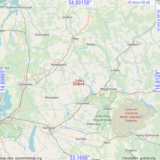
Dobra GPS coordinates[2]
53° 35' 10.5" North, 15° 18' 35.172" East
| Map corner | latitude | longitude |
|---|---|---|
| Upper-left | 54.00158°, | 14.60665° |
| Center: | 53.58625°, | 15.30977° |
| Lower-right: | 53.1668°, | 16.0129° |
| Map W x H: | 92.8×92.8 km | = 57.7×57.7mi |
| max Lat: | 54.83135° ⇑9.5% North |
| Dobra: | 53.58625° |
| min Lat: | ⇓90.5% South 49.21328° |
| min Long | Dobra | max Long |
| 14.20249° | 15.30977° | 24.03723° |
| W 3.6%⇐ | ⇒96.4% E |
Elevation
Elevation of Dobra is 79 m = 259 ft, and this is 112.4 m = 369 ft below average elevation for this country.
| Max E: |
974 m = 3196 ft | 88.9% |
| Avg. | 191.4 m = 628 ft | |
| Dobra | 79 m = 259 ft | |
Min E: |
-3 m = -10 ft | 11.1% |
See also: Poland elevation on elevation.city.
Geographical zone
Dobra is located in North temperate zone (between Tropic of Cancer and the Arctic Circle). Distance of this North polar circle is 1442.9 km =896.6 mi to North.| Distance of | km | miles | from Dobra |
|---|---|---|---|
| North Pole | 4048.8 | 2515.8 | to North |
| Arctic Circle | 1442.9 | 896.6 | to North |
| Tropic Cancer | 3352.3 | 2083 | to South |
| Equator | 5958.2 | 3702.3 | to South |


Nearby cities:
15 places around Dobra: (largest is in red/bold)
• Chociwel
13.4 km =8.3 mi,  173°
173°
• Dobrzany
26.5 km =16.5 mi,  162°
162°
• Goleniów
31.9 km =19.8 mi,  265°
265°
• Ińsko
23.1 km =14.4 mi,  136°
136°
• Marianowo
22.8 km =14.2 mi,  187°
187°
• Maszewo
19.2 km =11.9 mi,  238°
238°
• Mosty
23.7 km =14.7 mi,  259°
259°
• Nowogard
16.1 km =10 mi,  307°
307°
• Osina
19.7 km =12.2 mi,  275°
275°
• Płoty
24.1 km =15 mi,  353°
353°
• Radowo Małe
12.7 km =7.9 mi,  45°
45°
• Resko
21.7 km =13.5 mi,  16°
16°
• Stara Dąbrowa
21.3 km =13.2 mi,  210°
210°
• Węgorzyno
17.3 km =10.7 mi,  106°
106°
• Łobez
21.4 km =13.3 mi,  74°
74°
Sources, notices
• [Note1] Compared only with cities in Poland existing in our database
• [Src1] Map data: © OpenStreetMap contributors (CC-BY-SA)
• [Src2] Other city data from geonames.org with taken over terms of usage.
• [Src3] Geographical zone / Annual Mean Temperature by Robert A. Rohde @ Wikipedia
