Międzyrzecz geodata
Międzyrzecz (Lubusz) is a seat of a second-order administrative division; located in Poland in Europe/Warsaw (GMT+2) time zone. With population of 18,669 people, there are 261 cities with bigger population in this country. Compared to other cities in Poland, 75.6% of cities are located further ↓South; 94.9% of cities are located further →East and 94.2% of cities have higher elevation than Międzyrzecz. Note1


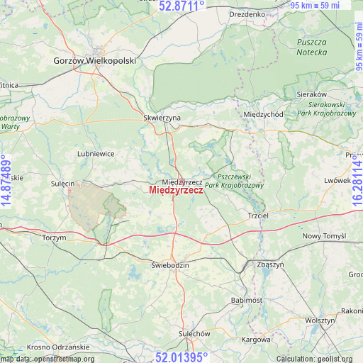
Międzyrzecz GPS coordinates[2]
52° 26' 40.596" North, 15° 34' 40.836" East
| Map corner | latitude | longitude |
|---|---|---|
| Upper-left | 52.8711°, | 14.87489° |
| Center: | 52.44461°, | 15.57801° |
| Lower-right: | 52.01395°, | 16.28114° |
| Map W x H: | 95.3×95.3 km | = 59.2×59.2mi |
| max Lat: | 54.83135° ⇑24.4% North |
| Międzyrzecz: | 52.44461° |
| min Lat: | ⇓75.6% South 49.21328° |
| min Long | Międzyrzecz | max Long |
| 14.20249° | 15.57801° | 24.03723° |
| W 5.1%⇐ | ⇒94.9% E |
Elevation
Elevation of Międzyrzecz is 51 m = 167 ft, and this is 140.4 m = 461 ft below average elevation for this country.
| Max E: |
974 m = 3196 ft | 94.2% |
| Avg. | 191.4 m = 628 ft | |
| Międzyrzecz | 51 m = 167 ft | |
Min E: |
-3 m = -10 ft | 5.8% |
See also: Poland elevation on elevation.city.
Geographical zone
Międzyrzecz is located in North temperate zone (between Tropic of Cancer and the Arctic Circle). Distance of this North polar circle is 1569.9 km =975.5 mi to North.| Distance of | km | miles | from Międzyrzecz |
|---|---|---|---|
| North Pole | 4175.8 | 2594.7 | to North |
| Arctic Circle | 1569.9 | 975.5 | to North |
| Tropic Cancer | 3225.4 | 2004.2 | to South |
| Equator | 5831.3 | 3623.4 | to South |


Nearby cities:
15 places around Międzyrzecz: (largest is in red/bold)
• Bledzew
13.7 km =8.5 mi,  305°
305°
• Brójce
15.6 km =9.7 mi,  155°
155°
• Glisno
23 km =14.3 mi,  278°
278°
• Lubniewice
23.6 km =14.7 mi,  289°
289°
• Lubrza
18.1 km =11.2 mi,  210°
210°
• Przytoczna
16.3 km =10.1 mi,  24°
24°
• Pszczew
14.3 km =8.9 mi,  75°
75°
• Sieniawa
16.3 km =10.1 mi,  236°
236°
• Skwierzyna
17.8 km =11.1 mi,  344°
344°
• Szczaniec
20.8 km =12.9 mi, 160°
• Trzciel
21.9 km =13.6 mi,  113°
113°
• Wilkowo
22.4 km =13.9 mi,  199°
199°
• Łagów
22.6 km =14 mi, 237°
• Łowyń
23.2 km =14.4 mi,  74°
74°
• Świebodzin
22.1 km =13.7 mi,  187°
187°
Sources, notices
• [Note1] Compared only with cities in Poland existing in our database
• [Src1] Map data: © OpenStreetMap contributors (CC-BY-SA)
• [Src2] Other city data from geonames.org with taken over terms of usage.
• [Src3] Geographical zone / Annual Mean Temperature by Robert A. Rohde @ Wikipedia
