Kwilcz geodata
Kwilcz (Greater Poland) is a seat of a third-order administrative division; located in Poland in Europe/Warsaw (GMT+2) time zone. With population of 2,746 people, there are 1150 cities with bigger population in this country. Compared to other cities in Poland, 77.2% of cities are located further ↓South; 92% of cities are located further →East and 79.3% of cities have higher elevation than Kwilcz. Note1


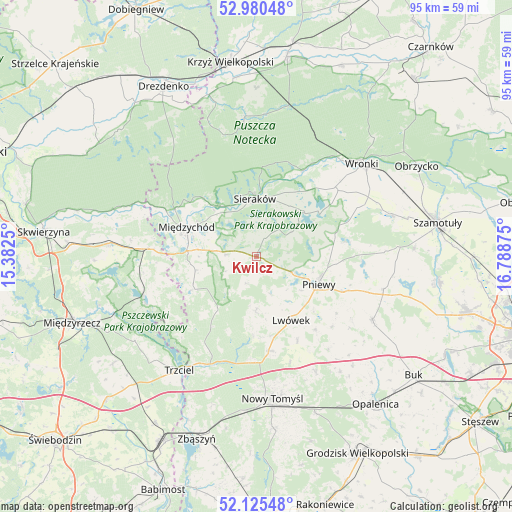
Kwilcz GPS coordinates[2]
52° 33' 18.216" North, 16° 5' 8.232" East
| Map corner | latitude | longitude |
|---|---|---|
| Upper-left | 52.98048°, | 15.3825° |
| Center: | 52.55506°, | 16.08562° |
| Lower-right: | 52.12548°, | 16.78875° |
| Map W x H: | 95.1×95.1 km | = 59.1×59.1mi |
| max Lat: | 54.83135° ⇑22.8% North |
| Kwilcz: | 52.55506° |
| min Lat: | ⇓77.2% South 49.21328° |
| min Long | Kwilcz | max Long |
| 14.20249° | 16.08562° | 24.03723° |
| W 8%⇐ | ⇒92% E |
Elevation
Elevation of Kwilcz is 101 m = 331 ft, and this is 90.4 m = 297 ft below average elevation for this country.
| Max E: |
974 m = 3196 ft | 79.3% |
| Avg. | 191.4 m = 628 ft | |
| Kwilcz | 101 m = 331 ft | |
Min E: |
-3 m = -10 ft | 20.7% |
See also: Poland elevation on elevation.city.
Geographical zone
Kwilcz is located in North temperate zone (between Tropic of Cancer and the Arctic Circle). Distance of this North polar circle is 1557.6 km =967.8 mi to North.| Distance of | km | miles | from Kwilcz |
|---|---|---|---|
| North Pole | 4163.5 | 2587.1 | to North |
| Arctic Circle | 1557.6 | 967.8 | to North |
| Tropic Cancer | 3237.7 | 2011.8 | to South |
| Equator | 5843.6 | 3631 | to South |


Nearby cities:
15 places around Kwilcz: (largest is in red/bold)
• Brody
19.2 km =11.9 mi,  132°
132°
• Chrzypsko Wielkie
12.6 km =7.8 mi,  49°
49°
• Duszniki
24.8 km =15.4 mi,  119°
119°
• Kuślin
26.3 km =16.3 mi,  143°
143°
• Lutom
8.8 km =5.5 mi,  25°
25°
• Lwówek
13.5 km =8.4 mi,  151°
151°
• Miedzichowo
21.7 km =13.5 mi,  203°
203°
• Międzychód
13.6 km =8.5 mi,  290°
290°
• Ostroróg
25.9 km =16.1 mi,  72°
72°
• Pakosław
17.3 km =10.7 mi, 140°
• Pniewy
12.6 km =7.8 mi,  113°
113°
• Pszczew
22.3 km =13.9 mi,  247°
247°
• Sieraków
10.7 km =6.6 mi,  358°
358°
• Trzciel
25.6 km =15.9 mi,  214°
214°
• Łowyń
13.4 km =8.3 mi,  243°
243°
Sources, notices
• [Note1] Compared only with cities in Poland existing in our database
• [Src1] Map data: © OpenStreetMap contributors (CC-BY-SA)
• [Src2] Other city data from geonames.org with taken over terms of usage.
• [Src3] Geographical zone / Annual Mean Temperature by Robert A. Rohde @ Wikipedia
