Łowyń geodata
Łowyń (Greater Poland) is a populated place; located in Poland in Europe/Warsaw (GMT+2) time zone. With population of 671 people, there are 3128 cities with bigger population in this country. Compared to other cities in Poland, 76.4% of cities are located further ↓South; 93% of cities are located further →East and 88.1% of cities have higher elevation than Łowyń. Note1
Administrative division(s):
- Level 1: Greater Poland
- Level 2: Powiat międzychodzki
- Level 3: Międzychód


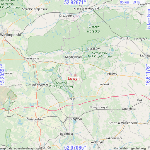
Łowyń GPS coordinates[2]
52° 30' 2.736" North, 15° 54' 31.068" East
| Map corner | latitude | longitude |
|---|---|---|
| Upper-left | 52.92671°, | 15.20551° |
| Center: | 52.50076°, | 15.90863° |
| Lower-right: | 52.07065°, | 16.61176° |
| Map W x H: | 95.2×95.2 km | = 59.2×59.2mi |
| max Lat: | 54.83135° ⇑23.6% North |
| Łowyń: | 52.50076° |
| min Lat: | ⇓76.4% South 49.21328° |
| min Long | Łowyń | max Long |
| 14.20249° | 15.90863° | 24.03723° |
| W 7%⇐ | ⇒93% E |
Elevation
Elevation of Łowyń is 81 m = 266 ft, and this is 110.4 m = 362 ft below average elevation for this country.
| Max E: |
974 m = 3196 ft | 88.1% |
| Avg. | 191.4 m = 628 ft | |
| Łowyń | 81 m = 266 ft | |
Min E: |
-3 m = -10 ft | 11.9% |
See also: Poland elevation on elevation.city.
Geographical zone
Łowyń is located in North temperate zone (between Tropic of Cancer and the Arctic Circle). Distance of this North polar circle is 1563.6 km =971.6 mi to North.| Distance of | km | miles | from Łowyń |
|---|---|---|---|
| North Pole | 4169.5 | 2590.8 | to North |
| Arctic Circle | 1563.6 | 971.6 | to North |
| Tropic Cancer | 3231.6 | 2008 | to South |
| Equator | 5837.5 | 3627.3 | to South |


Nearby cities:
15 places around Łowyń: (largest is in red/bold)
• Brójce
25.9 km =16.1 mi,  217°
217°
• Chrzypsko Wielkie
25.8 km =16 mi,  56°
56°
• Kwilcz
13.4 km =8.3 mi, 63°
• Lutom
21 km =13 mi,  48°
48°
• Lwówek
19.4 km =12.1 mi,  107°
107°
• Miedzichowo
14.3 km =8.9 mi,  166°
166°
• Międzychód
10.9 km =6.8 mi,  355°
355°
• Międzyrzecz
23.2 km =14.4 mi,  254°
254°
• Nowy Tomyśl
25.1 km =15.6 mi,  143°
143°
• Pakosław
24.1 km =15 mi, 107°
• Pniewy
23.6 km =14.7 mi,  87°
87°
• Przytoczna
17.7 km =11 mi,  298°
298°
• Pszczew
9 km =5.6 mi, 253°
• Sieraków
20.4 km =12.7 mi,  34°
34°
• Trzciel
15.3 km =9.5 mi,  189°
189°
Sources, notices
• [Note1] Compared only with cities in Poland existing in our database
• [Src1] Map data: © OpenStreetMap contributors (CC-BY-SA)
• [Src2] Other city data from geonames.org with taken over terms of usage.
• [Src3] Geographical zone / Annual Mean Temperature by Robert A. Rohde @ Wikipedia
