Międzychód geodata
Międzychód (Greater Poland) is a seat of a second-order administrative division; located in Poland in Europe/Warsaw (GMT+2) time zone. With population of 10,994 people, there are 417 cities with bigger population in this country. Compared to other cities in Poland, 77.9% of cities are located further ↓South; 93.1% of cities are located further →East and 95.4% of cities have higher elevation than Międzychód. Note1
Administrative division(s):
- Level 1: Greater Poland
- Level 2: Powiat międzychodzki
- Level 3: Międzychód


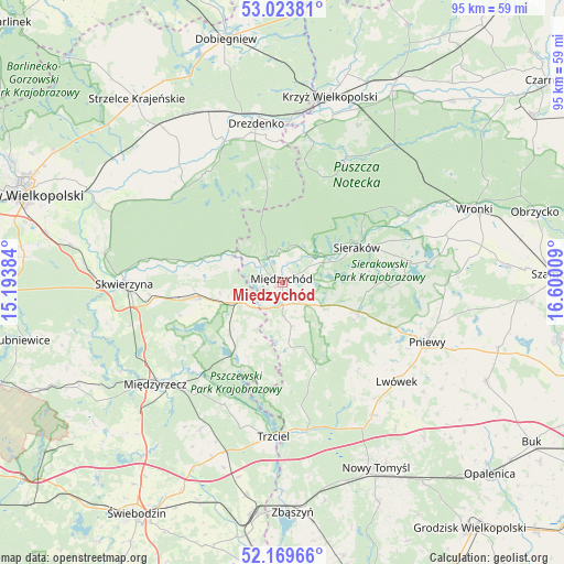
Międzychód GPS coordinates[2]
52° 35' 55.752" North, 15° 53' 49.056" East
| Map corner | latitude | longitude |
|---|---|---|
| Upper-left | 53.02381°, | 15.19384° |
| Center: | 52.59882°, | 15.89696° |
| Lower-right: | 52.16966°, | 16.60009° |
| Map W x H: | 95×95 km | = 59×59mi |
| max Lat: | 54.83135° ⇑22.1% North |
| Międzychód: | 52.59882° |
| min Lat: | ⇓77.9% South 49.21328° |
| min Long | Międzychód | max Long |
| 14.20249° | 15.89696° | 24.03723° |
| W 6.9%⇐ | ⇒93.1% E |
Elevation
Elevation of Międzychód is 37 m = 121 ft, and this is 154.4 m = 507 ft below average elevation for this country.
| Max E: |
974 m = 3196 ft | 95.4% |
| Avg. | 191.4 m = 628 ft | |
| Międzychód | 37 m = 121 ft | |
Min E: |
-3 m = -10 ft | 4.6% |
See also: Poland elevation on elevation.city.
Geographical zone
Międzychód is located in North temperate zone (between Tropic of Cancer and the Arctic Circle). Distance of this North polar circle is 1552.7 km =964.8 mi to North.| Distance of | km | miles | from Międzychód |
|---|---|---|---|
| North Pole | 4158.6 | 2584 | to North |
| Arctic Circle | 1552.7 | 964.8 | to North |
| Tropic Cancer | 3242.5 | 2014.8 | to South |
| Equator | 5848.4 | 3634 | to South |


Nearby cities:
15 places around Międzychód: (largest is in red/bold)
• Chrzypsko Wielkie
22.6 km =14 mi,  81°
81°
• Drawsko
29.8 km =18.5 mi,  17°
17°
• Drezdenko
27 km =16.8 mi,  350°
350°
• Kwilcz
13.6 km =8.5 mi,  110°
110°
• Lutom
16.8 km =10.4 mi, 79°
• Lwówek
25.5 km =15.8 mi,  131°
131°
• Miedzichowo
25.1 km =15.6 mi,  170°
170°
• Międzyrzecz
27.6 km =17.1 mi,  231°
231°
• Pniewy
26.3 km =16.3 mi, 112°
• Przytoczna
14.9 km =9.3 mi,  260°
260°
• Pszczew
15.6 km =9.7 mi,  209°
209°
• Sieraków
13.7 km =8.5 mi,  64°
64°
• Skwierzyna
26.4 km =16.4 mi,  270°
270°
• Trzciel
26 km =16.2 mi,  183°
183°
• Łowyń
10.9 km =6.8 mi, 175°
Sources, notices
• [Note1] Compared only with cities in Poland existing in our database
• [Src1] Map data: © OpenStreetMap contributors (CC-BY-SA)
• [Src2] Other city data from geonames.org with taken over terms of usage.
• [Src3] Geographical zone / Annual Mean Temperature by Robert A. Rohde @ Wikipedia
