Brójce geodata
Brójce (Lubusz) is a populated place; located in Poland in Europe/Warsaw (GMT+2) time zone. With population of 1,050 people, there are 2405 cities with bigger population in this country. Compared to other cities in Poland, 73% of cities are located further ↓South; 94.5% of cities are located further →East and 91.6% of cities have higher elevation than Brójce. Note1


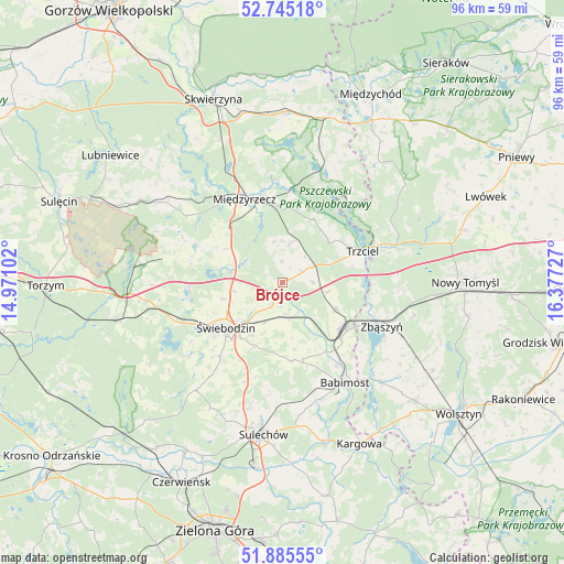
Brójce GPS coordinates[2]
52° 19' 2.82" North, 15° 40' 26.904" East
| Map corner | latitude | longitude |
|---|---|---|
| Upper-left | 52.74518°, | 14.97102° |
| Center: | 52.31745°, | 15.67414° |
| Lower-right: | 51.88555°, | 16.37727° |
| Map W x H: | 95.6×95.6 km | = 59.4×59.4mi |
| max Lat: | 54.83135° ⇑27% North |
| Brójce: | 52.31745° |
| min Lat: | ⇓73% South 49.21328° |
| min Long | Brójce | max Long |
| 14.20249° | 15.67414° | 24.03723° |
| W 5.5%⇐ | ⇒94.5% E |
Elevation
Elevation of Brójce is 67 m = 220 ft, and this is 124.4 m = 408 ft below average elevation for this country.
| Max E: |
974 m = 3196 ft | 91.6% |
| Avg. | 191.4 m = 628 ft | |
| Brójce | 67 m = 220 ft | |
Min E: |
-3 m = -10 ft | 8.4% |
See also: Poland elevation on elevation.city.
Geographical zone
Brójce is located in North temperate zone (between Tropic of Cancer and the Arctic Circle). Distance of this North polar circle is 1584 km =984.3 mi to North.| Distance of | km | miles | from Brójce |
|---|---|---|---|
| North Pole | 4189.9 | 2603.5 | to North |
| Arctic Circle | 1584 | 984.3 | to North |
| Tropic Cancer | 3211.2 | 1995.3 | to South |
| Equator | 5817.2 | 3614.6 | to South |


Nearby cities:
15 places around Brójce: (largest is in red/bold)
• Babimost
19.9 km =12.4 mi,  148°
148°
• Lubrza
15.8 km =9.8 mi,  264°
264°
• Miedzichowo
20.4 km =12.7 mi,  71°
71°
• Międzyrzecz
15.6 km =9.7 mi,  335°
335°
• Pszczew
19.2 km =11.9 mi,  22°
22°
• Sieniawa
20.8 km =12.9 mi,  284°
284°
• Skąpe
23.5 km =14.6 mi,  218°
218°
• Szczaniec
5.4 km =3.4 mi,  174°
174°
• Trzciel
14.5 km =9 mi, 68°
• Wilkowo
15.7 km =9.8 mi,  243°
243°
• Zbąszynek
12.7 km =7.9 mi,  130°
130°
• Zbąszyń
18.6 km =11.6 mi,  113°
113°
• Łagów
25.7 km =16 mi,  274°
274°
• Łowyń
25.9 km =16.1 mi,  37°
37°
• Świebodzin
12.3 km =7.6 mi,  230°
230°
Sources, notices
• [Note1] Compared only with cities in Poland existing in our database
• [Src1] Map data: © OpenStreetMap contributors (CC-BY-SA)
• [Src2] Other city data from geonames.org with taken over terms of usage.
• [Src3] Geographical zone / Annual Mean Temperature by Robert A. Rohde @ Wikipedia
