Dalachów geodata
Dalachów (Opole Voivodeship) is a populated place; located in Poland in Europe/Warsaw (GMT+2) time zone. With population of 1,295 people, there are 2096 cities with bigger population in this country. Compared to other cities in Poland, 53.2% of cities are located further ↑North; 67% of cities are located further →East and 59.4% of cities have lower elevation than Dalachów. Note1


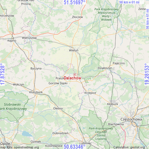
Dalachów GPS coordinates[2]
51° 4' 38.352" North, 18° 34' 42.24" East
| Map corner | latitude | longitude |
|---|---|---|
| Upper-left | 51.51697°, | 17.87528° |
| Center: | 51.07732°, | 18.5784° |
| Lower-right: | 50.63346°, | 19.28153° |
| Map W x H: | 98.2×98.2 km | = 61×61mi |
| max Lat: | 54.83135° ⇑53.2% North |
| Dalachów: | 51.07732° |
| min Lat: | ⇓46.8% South 49.21328° |
| min Long | Dalachów | max Long |
| 14.20249° | 18.5784° | 24.03723° |
| W 33%⇐ | ⇒67% E |
Elevation
Elevation of Dalachów is 199 m = 653 ft, and this is 7.6 m = 25 ft above average elevation for this country.
| Max E: |
974 m = 3196 ft | 40.6% |
| Dalachów | 199 m 653 ft | |
| Avg. | 191.4 m = 628 ft | |
Min E: |
-3 m = -10 ft | 59.4% |
See also: Poland elevation on elevation.city.
Geographical zone
Dalachów is located in North temperate zone (between Tropic of Cancer and the Arctic Circle). Distance of this North polar circle is 1721.9 km =1069.9 mi to North.| Distance of | km | miles | from Dalachów |
|---|---|---|---|
| North Pole | 4327.8 | 2689.2 | to North |
| Arctic Circle | 1721.9 | 1069.9 | to North |
| Tropic Cancer | 3073.3 | 1909.7 | to South |
| Equator | 5679.3 | 3529 | to South |


Nearby cities:
15 places around Dalachów: (largest is in red/bold)
• Gorzów Śląski
12.1 km =7.5 mi,  243°
243°
• Kowale
7.3 km =4.5 mi,  272°
272°
• Krzepice
15.9 km =9.9 mi,  138°
138°
• Mokrsko
12.9 km =8 mi,  331°
331°
• Ożarów
8.9 km =5.5 mi, 327°
• Praszka
9.1 km =5.7 mi,  253°
253°
• Przedmość
10.1 km =6.3 mi,  280°
280°
• Pątnów
7.9 km =4.9 mi,  19°
19°
• Radłow
16.3 km =10.1 mi,  190°
190°
• Rudniki
4.5 km =2.8 mi,  162°
162°
• Starokrzepice
15.2 km =9.4 mi, 159°
• Wieluń
16 km =9.9 mi,  357°
357°
• Wierzchlas
15.4 km =9.6 mi, 23°
• Wróblew
14.2 km =8.8 mi,  302°
302°
• Zdziechowice
13.3 km =8.3 mi, 278°
Sources, notices
• [Note1] Compared only with cities in Poland existing in our database
• [Src1] Map data: © OpenStreetMap contributors (CC-BY-SA)
• [Src2] Other city data from geonames.org with taken over terms of usage.
• [Src3] Geographical zone / Annual Mean Temperature by Robert A. Rohde @ Wikipedia
