Rudniki geodata
Rudniki (Opole Voivodeship) is a populated place; located in Poland in Europe/Warsaw (GMT+2) time zone. With population of 979 people, there are 2540 cities with bigger population in this country. Compared to other cities in Poland, 54.3% of cities are located further ↑North; 66.7% of cities are located further →East and 69.4% of cities have lower elevation than Rudniki. Note1


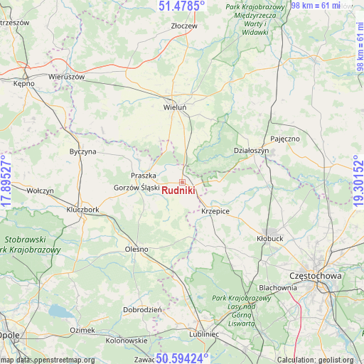
Rudniki GPS coordinates[2]
51° 2' 18.528" North, 18° 35' 54.204" East
| Map corner | latitude | longitude |
|---|---|---|
| Upper-left | 51.4785°, | 17.89527° |
| Center: | 51.03848°, | 18.59839° |
| Lower-right: | 50.59424°, | 19.30152° |
| Map W x H: | 98.3×98.3 km | = 61.1×61.1mi |
| max Lat: | 54.83135° ⇑54.3% North |
| Rudniki: | 51.03848° |
| min Lat: | ⇓45.7% South 49.21328° |
| min Long | Rudniki | max Long |
| 14.20249° | 18.59839° | 24.03723° |
| W 33.3%⇐ | ⇒66.7% E |
Elevation
Elevation of Rudniki is 227 m = 745 ft, and this is 35.6 m = 117 ft above average elevation for this country.
| Max E: |
974 m = 3196 ft | 30.6% |
| Rudniki | 227 m 745 ft | |
| Avg. | 191.4 m = 628 ft | |
Min E: |
-3 m = -10 ft | 69.4% |
See also: Poland elevation on elevation.city.
Geographical zone
Rudniki is located in North temperate zone (between Tropic of Cancer and the Arctic Circle). Distance of this North polar circle is 1726.2 km =1072.6 mi to North.| Distance of | km | miles | from Rudniki |
|---|---|---|---|
| North Pole | 4332.1 | 2691.8 | to North |
| Arctic Circle | 1726.2 | 1072.6 | to North |
| Tropic Cancer | 3069 | 1907 | to South |
| Equator | 5674.9 | 3526.2 | to South |


Nearby cities:
15 places around Rudniki: (largest is in red/bold)
• Dalachów
4.5 km =2.8 mi,  342°
342°
• Gorzów Śląski
12.3 km =7.6 mi,  264°
264°
• Kowale
9.8 km =6.1 mi,  297°
297°
• Krzepice
11.8 km =7.3 mi,  129°
129°
• Lipie
14.2 km =8.8 mi,  101°
101°
• Mokrsko
17.4 km =10.8 mi,  333°
333°
• Opatów
18 km =11.2 mi,  120°
120°
• Ożarów
13.3 km =8.3 mi, 332°
• Praszka
10.3 km =6.4 mi,  279°
279°
• Przedmość
12.9 km =8 mi, 298°
• Pątnów
11.8 km =7.3 mi,  6°
6°
• Radłow
12.5 km =7.8 mi,  200°
200°
• Starokrzepice
10.7 km =6.6 mi,  158°
158°
• Wróblew
18 km =11.2 mi,  311°
311°
• Zdziechowice
15.9 km =9.9 mi,  293°
293°
Sources, notices
• [Note1] Compared only with cities in Poland existing in our database
• [Src1] Map data: © OpenStreetMap contributors (CC-BY-SA)
• [Src2] Other city data from geonames.org with taken over terms of usage.
• [Src3] Geographical zone / Annual Mean Temperature by Robert A. Rohde @ Wikipedia
