Morzyczyn geodata
Morzyczyn (West Pomerania) is a populated place; located in Poland in Europe/Warsaw (GMT+2) time zone. With population of 859 people, there are 2759 cities with bigger population in this country. Compared to other cities in Poland, 88% of cities are located further ↓South; 98.4% of cities are located further →East and 97.9% of cities have higher elevation than Morzyczyn. Note1


Morzyczyn GPS coordinates[2]
53° 21' 10.656" North, 14° 55' 7.5" East
| Map corner | latitude | longitude |
|---|---|---|
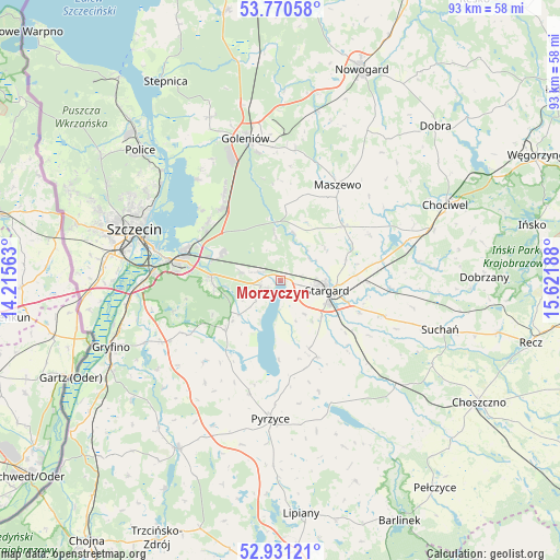
| Upper-left | 53.77058°, | 14.21563° |
| Center: | 53.35296°, | 14.91875° |
| Lower-right: | 52.93121°, | 15.62188° |
| Map W x H: | 93.3×93.3 km | = 58×58mi |
| max Lat: | 54.83135° ⇑12% North |
| Morzyczyn: | 53.35296° |
| min Lat: | ⇓88% South 49.21328° |
| min Long | Morzyczyn | max Long |
| 14.20249° | 14.91875° | 24.03723° |
| W 1.6%⇐ | ⇒98.4% E |
Elevation
Elevation of Morzyczyn is 16 m = 52 ft, and this is 175.4 m = 575 ft below average elevation for this country.
| Max E: |
974 m = 3196 ft | 97.9% |
| Avg. | 191.4 m = 628 ft | |
| Morzyczyn | 16 m = 52 ft | |
Min E: |
-3 m = -10 ft | 2.1% |
See also: Poland elevation on elevation.city.
Geographical zone
Morzyczyn is located in North temperate zone (between Tropic of Cancer and the Arctic Circle). Distance of this North polar circle is 1468.9 km =912.7 mi to North.| Distance of | km | miles | from Morzyczyn |
|---|---|---|---|
| North Pole | 4074.8 | 2532 | to North |
| Arctic Circle | 1468.9 | 912.7 | to North |
| Tropic Cancer | 3326.4 | 2066.9 | to South |
| Equator | 5932.3 | 3686.2 | to South |


Nearby cities:
15 places around Morzyczyn: (largest is in red/bold)
• Bielice
21.2 km =13.2 mi,  216°
216°
• Dolice
26.1 km =16.2 mi,  133°
133°
• Goleniów
24.2 km =15 mi,  345°
345°
• Kobylanka
3.3 km =2.1 mi,  254°
254°
• Kozielice
28.1 km =17.5 mi,  193°
193°
• Marianowo
23.3 km =14.5 mi,  81°
81°
• Maszewo
18.5 km =11.5 mi,  30°
30°
• Mosty
21.8 km =13.5 mi,  6°
6°
• Pyrzyce
23.1 km =14.4 mi,  184°
184°
• Stara Dąbrowa
16.8 km =10.4 mi,  62°
62°
• Stare Czarnowo
12.4 km =7.7 mi,  228°
228°
• Stargard
8.9 km =5.5 mi,  101°
101°
• Suchań
28.2 km =17.5 mi,  106°
106°
• Szczecin
25.7 km =16 mi,  289°
289°
• Warnice
12.1 km =7.5 mi,  155°
155°
Sources, notices
• [Note1] Compared only with cities in Poland existing in our database
• [Src1] Map data: © OpenStreetMap contributors (CC-BY-SA)
• [Src2] Other city data from geonames.org with taken over terms of usage.
• [Src3] Geographical zone / Annual Mean Temperature by Robert A. Rohde @ Wikipedia
