Bielice geodata
Bielice (West Pomerania) is a seat of a third-order administrative division; located in Poland in Europe/Warsaw (GMT+2) time zone. With population of 560 people, there are 3377 cities with bigger population in this country. Compared to other cities in Poland, 86.4% of cities are located further ↓South; 99.1% of cities are located further →East and 96.4% of cities have higher elevation than Bielice. Note1


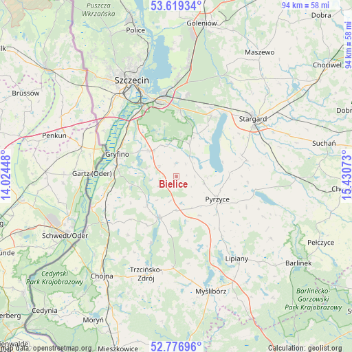
Bielice GPS coordinates[2]
53° 12' 0.792" North, 14° 43' 39.36" East
| Map corner | latitude | longitude |
|---|---|---|
| Upper-left | 53.61934°, | 14.02448° |
| Center: | 53.20022°, | 14.7276° |
| Lower-right: | 52.77696°, | 15.43073° |
| Map W x H: | 93.7×93.7 km | = 58.2×58.2mi |
| max Lat: | 54.83135° ⇑13.6% North |
| Bielice: | 53.20022° |
| min Lat: | ⇓86.4% South 49.21328° |
| min Long | Bielice | max Long |
| 14.20249° | 14.7276° | 24.03723° |
| W 0.9%⇐ | ⇒99.1% E |
Elevation
Elevation of Bielice is 28 m = 92 ft, and this is 163.4 m = 536 ft below average elevation for this country.
| Max E: |
974 m = 3196 ft | 96.4% |
| Avg. | 191.4 m = 628 ft | |
| Bielice | 28 m = 92 ft | |
Min E: |
-3 m = -10 ft | 3.6% |
See also: Poland elevation on elevation.city.
Geographical zone
Bielice is located in North temperate zone (between Tropic of Cancer and the Arctic Circle). Distance of this North polar circle is 1485.9 km =923.3 mi to North.| Distance of | km | miles | from Bielice |
|---|---|---|---|
| North Pole | 4091.8 | 2542.5 | to North |
| Arctic Circle | 1485.9 | 923.3 | to North |
| Tropic Cancer | 3309.4 | 2056.4 | to South |
| Equator | 5915.3 | 3675.6 | to South |


Nearby cities:
15 places around Bielice: (largest is in red/bold)
• Banie
11.9 km =7.4 mi,  201°
201°
• Gryfino
17 km =10.6 mi,  290°
290°
• Kobylanka
18.7 km =11.6 mi,  30°
30°
• Kozielice
12.2 km =7.6 mi,  148°
148°
• Kołbaskowo
24.5 km =15.2 mi,  308°
308°
• Lipiany
27.2 km =16.9 mi,  143°
143°
• Lubanowo
11 km =6.8 mi,  224°
224°
• Morzyczyn
21.2 km =13.2 mi,  36°
36°
• Przecław
25.7 km =16 mi,  318°
318°
• Przelewice
25.6 km =15.9 mi,  114°
114°
• Pyrzyce
12.5 km =7.8 mi,  118°
118°
• Stare Czarnowo
9.4 km =5.8 mi,  21°
21°
• Stargard
26.3 km =16.3 mi,  54°
54°
• Warnice
18.7 km =11.6 mi,  71°
71°
• Widuchowa
23.9 km =14.9 mi,  250°
250°
Sources, notices
• [Note1] Compared only with cities in Poland existing in our database
• [Src1] Map data: © OpenStreetMap contributors (CC-BY-SA)
• [Src2] Other city data from geonames.org with taken over terms of usage.
• [Src3] Geographical zone / Annual Mean Temperature by Robert A. Rohde @ Wikipedia
