Stare Czarnowo geodata
Stare Czarnowo (West Pomerania) is a seat of a third-order administrative division; located in Poland in Europe/Warsaw (GMT+2) time zone. With population of 520 people, there are 3482 cities with bigger population in this country. Compared to other cities in Poland, 87.2% of cities are located further ↓South; 98.9% of cities are located further →East and 95.2% of cities have higher elevation than Stare Czarnowo. Note1
Administrative division(s):
- Level 1: West Pomerania
- Level 2: Powiat gryfiński
- Level 3: Stare Czarnowo


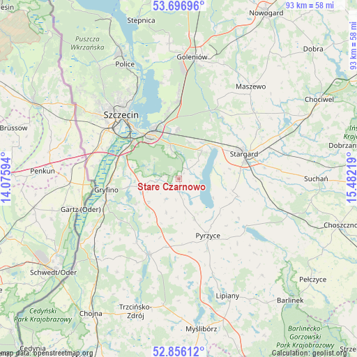
Stare Czarnowo GPS coordinates[2]
53° 16' 42.996" North, 14° 46' 44.616" East
| Map corner | latitude | longitude |
|---|---|---|
| Upper-left | 53.69696°, | 14.07594° |
| Center: | 53.27861°, | 14.77906° |
| Lower-right: | 52.85612°, | 15.48219° |
| Map W x H: | 93.5×93.5 km | = 58.1×58.1mi |
| max Lat: | 54.83135° ⇑12.8% North |
| Stare Czarnowo: | 53.27861° |
| min Lat: | ⇓87.2% South 49.21328° |
| min Long | Stare Czarnowo | max Long |
| 14.20249° | 14.77906° | 24.03723° |
| W 1.1%⇐ | ⇒98.9% E |
Elevation
Elevation of Stare Czarnowo is 39 m = 128 ft, and this is 152.4 m = 500 ft below average elevation for this country.
| Max E: |
974 m = 3196 ft | 95.2% |
| Avg. | 191.4 m = 628 ft | |
| Stare Czarnowo | 39 m = 128 ft | |
Min E: |
-3 m = -10 ft | 4.8% |
See also: Poland elevation on elevation.city.
Geographical zone
Stare Czarnowo is located in North temperate zone (between Tropic of Cancer and the Arctic Circle). Distance of this North polar circle is 1477.1 km =917.8 mi to North.| Distance of | km | miles | from Stare Czarnowo |
|---|---|---|---|
| North Pole | 4083 | 2537.1 | to North |
| Arctic Circle | 1477.1 | 917.8 | to North |
| Tropic Cancer | 3318.1 | 2061.8 | to South |
| Equator | 5924 | 3681 | to South |


Nearby cities:
15 places around Stare Czarnowo: (largest is in red/bold)
• Banie
21.3 km =13.2 mi,  201°
201°
• Bielice
9.4 km =5.8 mi, 201°
• Gryfino
19.6 km =12.2 mi,  261°
261°
• Kobylanka
9.6 km =6 mi,  39°
39°
• Kozielice
19.3 km =12 mi,  171°
171°
• Kołbaskowo
23.5 km =14.6 mi,  285°
285°
• Lubanowo
19.9 km =12.4 mi,  213°
213°
• Morzyczyn
12.4 km =7.7 mi,  48°
48°
• Przecław
23 km =14.3 mi,  297°
297°
• Przelewice
27.7 km =17.2 mi,  134°
134°
• Pyrzyce
16.5 km =10.3 mi,  152°
152°
• Stara Dąbrowa
29 km =18 mi,  56°
56°
• Stargard
19.1 km =11.9 mi,  70°
70°
• Szczecin
22.5 km =14 mi,  318°
318°
• Warnice
14.6 km =9.1 mi,  100°
100°
Sources, notices
• [Note1] Compared only with cities in Poland existing in our database
• [Src1] Map data: © OpenStreetMap contributors (CC-BY-SA)
• [Src2] Other city data from geonames.org with taken over terms of usage.
• [Src3] Geographical zone / Annual Mean Temperature by Robert A. Rohde @ Wikipedia
