Warnice geodata
Warnice (West Pomerania) is a seat of a third-order administrative division; located in Poland in Europe/Warsaw (GMT+2) time zone. With population of 695 people, there are 3081 cities with bigger population in this country. Compared to other cities in Poland, 86.9% of cities are located further ↓South; 98.1% of cities are located further →East and 96.6% of cities have higher elevation than Warnice. Note1


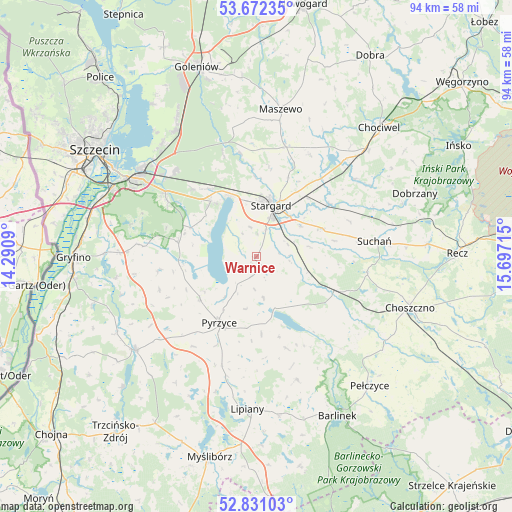
Warnice GPS coordinates[2]
53° 15' 13.536" North, 14° 59' 38.472" East
| Map corner | latitude | longitude |
|---|---|---|
| Upper-left | 53.67235°, | 14.2909° |
| Center: | 53.25376°, | 14.99402° |
| Lower-right: | 52.83103°, | 15.69715° |
| Map W x H: | 93.5×93.5 km | = 58.1×58.1mi |
| max Lat: | 54.83135° ⇑13.1% North |
| Warnice: | 53.25376° |
| min Lat: | ⇓86.9% South 49.21328° |
| min Long | Warnice | max Long |
| 14.20249° | 14.99402° | 24.03723° |
| W 1.9%⇐ | ⇒98.1% E |
Elevation
Elevation of Warnice is 26 m = 85 ft, and this is 165.4 m = 543 ft below average elevation for this country.
| Max E: |
974 m = 3196 ft | 96.6% |
| Avg. | 191.4 m = 628 ft | |
| Warnice | 26 m = 85 ft | |
Min E: |
-3 m = -10 ft | 3.4% |
See also: Poland elevation on elevation.city.
Geographical zone
Warnice is located in North temperate zone (between Tropic of Cancer and the Arctic Circle). Distance of this North polar circle is 1479.9 km =919.6 mi to North.| Distance of | km | miles | from Warnice |
|---|---|---|---|
| North Pole | 4085.8 | 2538.8 | to North |
| Arctic Circle | 1479.9 | 919.6 | to North |
| Tropic Cancer | 3315.3 | 2060 | to South |
| Equator | 5921.3 | 3679.3 | to South |


Nearby cities:
15 places around Warnice: (largest is in red/bold)
• Banie
27.9 km =17.3 mi,  232°
232°
• Bielice
18.7 km =11.6 mi,  251°
251°
• Dolice
15.6 km =9.7 mi,  116°
116°
• Kobylanka
13 km =8.1 mi,  321°
321°
• Kozielice
19.9 km =12.4 mi,  214°
214°
• Lipiany
27.9 km =17.3 mi,  183°
183°
• Marianowo
23.1 km =14.4 mi,  51°
51°
• Maszewo
27.3 km =17 mi,  9°
9°
• Morzyczyn
12.1 km =7.5 mi,  335°
335°
• Przelewice
17.5 km =10.9 mi,  161°
161°
• Pyrzyce
13.7 km =8.5 mi, 209°
• Stara Dąbrowa
21.2 km =13.2 mi,  28°
28°
• Stare Czarnowo
14.6 km =9.1 mi,  280°
280°
• Stargard
9.9 km =6.2 mi,  21°
21°
• Suchań
22.2 km =13.8 mi,  82°
82°
Sources, notices
• [Note1] Compared only with cities in Poland existing in our database
• [Src1] Map data: © OpenStreetMap contributors (CC-BY-SA)
• [Src2] Other city data from geonames.org with taken over terms of usage.
• [Src3] Geographical zone / Annual Mean Temperature by Robert A. Rohde @ Wikipedia
