Chróścina geodata
Chróścina (Opole Voivodeship) is a populated place; located in Poland in Europe/Warsaw (GMT+2) time zone. With population of 1,736 people, there are 1654 cities with bigger population in this country. Compared to other cities in Poland, 64.6% of cities are located further ↑North; 80.9% of cities are located further →East and 54.6% of cities have lower elevation than Chróścina. Note1


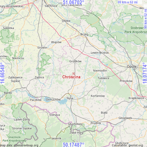
Chróścina GPS coordinates[2]
50° 37' 23.016" North, 17° 22' 6.996" East
| Map corner | latitude | longitude |
|---|---|---|
| Upper-left | 51.06702°, | 16.66549° |
| Center: | 50.62306°, | 17.36861° |
| Lower-right: | 50.17487°, | 18.07174° |
| Map W x H: | 99.2×99.2 km | = 61.6×61.6mi |
| max Lat: | 54.83135° ⇑64.6% North |
| Chróścina: | 50.62306° |
| min Lat: | ⇓35.4% South 49.21328° |
| min Long | Chróścina | max Long |
| 14.20249° | 17.36861° | 24.03723° |
| W 19.1%⇐ | ⇒80.9% E |
Elevation
Elevation of Chróścina is 184 m = 604 ft, and this is 7.4 m = 24 ft below average elevation for this country.
| Max E: |
974 m = 3196 ft | 45.4% |
| Avg. | 191.4 m = 628 ft | |
| Chróścina | 184 m = 604 ft | |
Min E: |
-3 m = -10 ft | 54.6% |
See also: Poland elevation on elevation.city.
Geographical zone
Chróścina is located in North temperate zone (between Tropic of Cancer and the Arctic Circle). Distance of this North polar circle is 1772.4 km =1101.3 mi to North.| Distance of | km | miles | from Chróścina |
|---|---|---|---|
| North Pole | 4378.3 | 2720.5 | to North |
| Arctic Circle | 1772.4 | 1101.3 | to North |
| Tropic Cancer | 3022.8 | 1878.3 | to South |
| Equator | 5628.8 | 3497.6 | to South |


Nearby cities:
15 places around Chróścina: (largest is in red/bold)
• Grodków
8.4 km =5.2 mi,  7°
7°
• Jasienica Dolna
15 km =9.3 mi,  141°
141°
• Kamiennik
16.5 km =10.3 mi,  249°
249°
• Michałow
16.7 km =10.4 mi,  35°
35°
• Niemodlin
17.8 km =11.1 mi,  83°
83°
• Nysa
16.8 km =10.4 mi,  188°
188°
• Olszanka
20.6 km =12.8 mi,  22°
22°
• Pakosławice
8.7 km =5.4 mi,  181°
181°
• Pogorzela
20.3 km =12.6 mi,  25°
25°
• Prusinowice
9.9 km =6.2 mi,  164°
164°
• Przeworno
15.9 km =9.9 mi,  296°
296°
• Sidzina
7.9 km =4.9 mi,  134°
134°
• Skoroszyce
3.1 km =1.9 mi, 161°
• Tułowice
20.3 km =12.6 mi,  98°
98°
• Łambinowice
16.5 km =10.3 mi,  124°
124°
Sources, notices
• [Note1] Compared only with cities in Poland existing in our database
• [Src1] Map data: © OpenStreetMap contributors (CC-BY-SA)
• [Src2] Other city data from geonames.org with taken over terms of usage.
• [Src3] Geographical zone / Annual Mean Temperature by Robert A. Rohde @ Wikipedia
