Kamiennik geodata
Kamiennik (Opole Voivodeship) is a seat of a third-order administrative division; located in Poland in Europe/Warsaw (GMT+2) time zone. With population of 702 people, there are 3058 cities with bigger population in this country. Compared to other cities in Poland, 66% of cities are located further ↑North; 82.7% of cities are located further →East and 75.1% of cities have lower elevation than Kamiennik. Note1


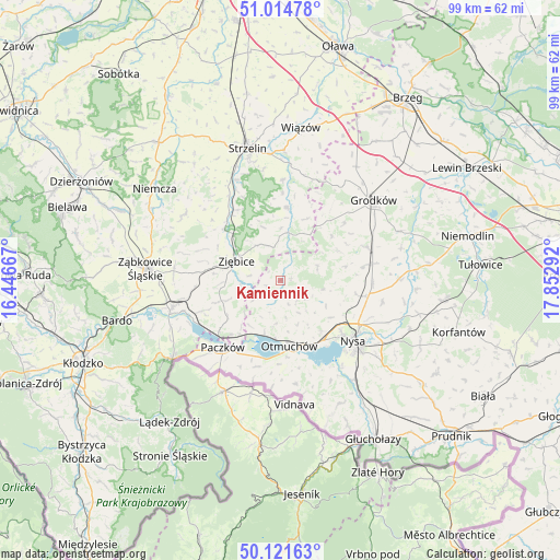
Kamiennik GPS coordinates[2]
50° 34' 13.152" North, 17° 8' 59.244" East
| Map corner | latitude | longitude |
|---|---|---|
| Upper-left | 51.01478°, | 16.44667° |
| Center: | 50.57032°, | 17.14979° |
| Lower-right: | 50.12163°, | 17.85292° |
| Map W x H: | 99.3×99.3 km | = 61.7×61.7mi |
| max Lat: | 54.83135° ⇑66% North |
| Kamiennik: | 50.57032° |
| min Lat: | ⇓34% South 49.21328° |
| min Long | Kamiennik | max Long |
| 14.20249° | 17.14979° | 24.03723° |
| W 17.3%⇐ | ⇒82.7% E |
Elevation
Elevation of Kamiennik is 247 m = 810 ft, and this is 55.6 m = 182 ft above average elevation for this country.
| Max E: |
974 m = 3196 ft | 24.9% |
| Kamiennik | 247 m 810 ft | |
| Avg. | 191.4 m = 628 ft | |
Min E: |
-3 m = -10 ft | 75.1% |
See also: Poland elevation on elevation.city.
Geographical zone
Kamiennik is located in North temperate zone (between Tropic of Cancer and the Arctic Circle). Distance of this North polar circle is 1778.3 km =1105 mi to North.| Distance of | km | miles | from Kamiennik |
|---|---|---|---|
| North Pole | 4384.2 | 2724.2 | to North |
| Arctic Circle | 1778.3 | 1105 | to North |
| Tropic Cancer | 3017 | 1874.7 | to South |
| Equator | 5622.9 | 3493.9 | to South |


Nearby cities:
15 places around Kamiennik: (largest is in red/bold)
• Chróścina
16.5 km =10.3 mi,  69°
69°
• Ciepłowody
20.6 km =12.8 mi,  304°
304°
• Henryków
13.5 km =8.4 mi,  313°
313°
• Kamienica
19.2 km =11.9 mi,  226°
226°
• Kamieniec Ząbkowicki
19.8 km =12.3 mi,  255°
255°
• Maciejowice
7.7 km =4.8 mi,  186°
186°
• Niedźwiedź
11 km =6.8 mi,  250°
250°
• Nysa
16.9 km =10.5 mi,  129°
129°
• Otmuchów
11.7 km =7.3 mi,  171°
171°
• Paczków
15.6 km =9.7 mi,  220°
220°
• Pakosławice
15.5 km =9.6 mi,  100°
100°
• Prusinowice
18.6 km =11.6 mi, 101°
• Przeworno
12.9 km =8 mi,  5°
5°
• Skoroszyce
16.7 km =10.4 mi,  79°
79°
• Ziębice
8.4 km =5.2 mi,  294°
294°
Sources, notices
• [Note1] Compared only with cities in Poland existing in our database
• [Src1] Map data: © OpenStreetMap contributors (CC-BY-SA)
• [Src2] Other city data from geonames.org with taken over terms of usage.
• [Src3] Geographical zone / Annual Mean Temperature by Robert A. Rohde @ Wikipedia
