Skoroszyce geodata
Skoroszyce (Opole Voivodeship) is a seat of a third-order administrative division; located in Poland in Europe/Warsaw (GMT+2) time zone. With population of 1,400 people, there are 1959 cities with bigger population in this country. Compared to other cities in Poland, 65.2% of cities are located further ↑North; 80.8% of cities are located further →East and 52.6% of cities have lower elevation than Skoroszyce. Note1


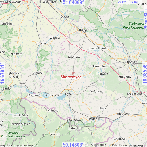
Skoroszyce GPS coordinates[2]
50° 35' 47.328" North, 17° 22' 56.748" East
| Map corner | latitude | longitude |
|---|---|---|
| Upper-left | 51.04069°, | 16.67931° |
| Center: | 50.59648°, | 17.38243° |
| Lower-right: | 50.14803°, | 18.08556° |
| Map W x H: | 99.3×99.3 km | = 61.7×61.7mi |
| max Lat: | 54.83135° ⇑65.2% North |
| Skoroszyce: | 50.59648° |
| min Lat: | ⇓34.8% South 49.21328° |
| min Long | Skoroszyce | max Long |
| 14.20249° | 17.38243° | 24.03723° |
| W 19.2%⇐ | ⇒80.8% E |
Elevation
Elevation of Skoroszyce is 179 m = 587 ft, and this is 12.4 m = 41 ft below average elevation for this country.
| Max E: |
974 m = 3196 ft | 47.4% |
| Avg. | 191.4 m = 628 ft | |
| Skoroszyce | 179 m = 587 ft | |
Min E: |
-3 m = -10 ft | 52.6% |
See also: Poland elevation on elevation.city.
Geographical zone
Skoroszyce is located in North temperate zone (between Tropic of Cancer and the Arctic Circle). Distance of this North polar circle is 1775.4 km =1103.2 mi to North.| Distance of | km | miles | from Skoroszyce |
|---|---|---|---|
| North Pole | 4381.3 | 2722.4 | to North |
| Arctic Circle | 1775.4 | 1103.2 | to North |
| Tropic Cancer | 3019.9 | 1876.5 | to South |
| Equator | 5625.8 | 3495.7 | to South |


Nearby cities:
15 places around Skoroszyce: (largest is in red/bold)
• Chróścina
3.1 km =1.9 mi,  341°
341°
• Grodków
11.3 km =7 mi,  0°
0°
• Jasienica Dolna
12.1 km =7.5 mi,  136°
136°
• Kamiennik
16.7 km =10.4 mi,  259°
259°
• Korfantów
19.4 km =12.1 mi,  128°
128°
• Maciejowice
20.2 km =12.6 mi,  238°
238°
• Michałow
18.7 km =11.6 mi,  28°
28°
• Niemodlin
17.5 km =10.9 mi,  73°
73°
• Nysa
14.1 km =8.8 mi,  193°
193°
• Pakosławice
5.9 km =3.7 mi, 191°
• Prusinowice
6.8 km =4.2 mi,  165°
165°
• Przeworno
18.2 km =11.3 mi,  303°
303°
• Sidzina
5.3 km =3.3 mi,  118°
118°
• Tułowice
19.1 km =11.9 mi,  90°
90°
• Łambinowice
14.2 km =8.8 mi, 117°
Sources, notices
• [Note1] Compared only with cities in Poland existing in our database
• [Src1] Map data: © OpenStreetMap contributors (CC-BY-SA)
• [Src2] Other city data from geonames.org with taken over terms of usage.
• [Src3] Geographical zone / Annual Mean Temperature by Robert A. Rohde @ Wikipedia
