Niemodlin geodata
Niemodlin (Opole Voivodeship) is a populated place; located in Poland in Europe/Warsaw (GMT+2) time zone. With population of 6,828 people, there are 551 cities with bigger population in this country. Compared to other cities in Poland, 64.1% of cities are located further ↑North; 79% of cities are located further →East and 54.2% of cities have higher elevation than Niemodlin. Note1


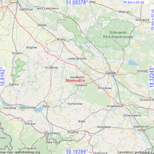
Niemodlin GPS coordinates[2]
50° 38' 31.2" North, 17° 37' 9.552" East
| Map corner | latitude | longitude |
|---|---|---|
| Upper-left | 51.08578°, | 16.9162° |
| Center: | 50.642°, | 17.61932° |
| Lower-right: | 50.19399°, | 18.32245° |
| Map W x H: | 99.2×99.2 km | = 61.6×61.6mi |
| max Lat: | 54.83135° ⇑64.1% North |
| Niemodlin: | 50.642° |
| min Lat: | ⇓35.9% South 49.21328° |
| min Long | Niemodlin | max Long |
| 14.20249° | 17.61932° | 24.03723° |
| W 21%⇐ | ⇒79% E |
Elevation
Elevation of Niemodlin is 161 m = 528 ft, and this is 30.4 m = 100 ft below average elevation for this country.
| Max E: |
974 m = 3196 ft | 54.2% |
| Avg. | 191.4 m = 628 ft | |
| Niemodlin | 161 m = 528 ft | |
Min E: |
-3 m = -10 ft | 45.8% |
See also: Poland elevation on elevation.city.
Geographical zone
Niemodlin is located in North temperate zone (between Tropic of Cancer and the Arctic Circle). Distance of this North polar circle is 1770.3 km =1100 mi to North.| Distance of | km | miles | from Niemodlin |
|---|---|---|---|
| North Pole | 4376.2 | 2719.2 | to North |
| Arctic Circle | 1770.3 | 1100 | to North |
| Tropic Cancer | 3024.9 | 1879.6 | to South |
| Equator | 5630.9 | 3498.9 | to South |


Nearby cities:
15 places around Niemodlin: (largest is in red/bold)
• Borkowice
12.9 km =8 mi,  31°
31°
• Chmielowice
17.5 km =10.9 mi,  87°
87°
• Chrościna
14.2 km =8.8 mi,  79°
79°
• Dąbrowa
10.3 km =6.4 mi,  63°
63°
• Jasienica Dolna
16.3 km =10.1 mi,  211°
211°
• Karczów
13.5 km =8.4 mi, 59°
• Komprachcice
14.6 km =9.1 mi, 92°
• Korfantów
17.1 km =10.6 mi,  184°
184°
• Lewin Brzeski
11.9 km =7.4 mi,  359°
359°
• Michałow
13.8 km =8.6 mi,  325°
325°
• Sidzina
14.2 km =8.8 mi,  237°
237°
• Skorogoszcz
13.8 km =8.6 mi,  18°
18°
• Tułowice
5.7 km =3.5 mi,  155°
155°
• Łambinowice
12.2 km =7.6 mi,  199°
199°
• Łosiów
17 km =10.6 mi,  347°
347°
Sources, notices
• [Note1] Compared only with cities in Poland existing in our database
• [Src1] Map data: © OpenStreetMap contributors (CC-BY-SA)
• [Src2] Other city data from geonames.org with taken over terms of usage.
• [Src3] Geographical zone / Annual Mean Temperature by Robert A. Rohde @ Wikipedia
