Przeworno geodata
Przeworno (Lower Silesia) is a populated place; located in Poland in Europe/Warsaw (GMT+2) time zone. With population of 1,259 people, there are 2117 cities with bigger population in this country. Compared to other cities in Poland, 62.9% of cities are located further ↑North; 82.5% of cities are located further →East and 56% of cities have lower elevation than Przeworno. Note1


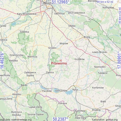
Przeworno GPS coordinates[2]
50° 41' 10.644" North, 17° 9' 57.168" East
| Map corner | latitude | longitude |
|---|---|---|
| Upper-left | 51.12965°, | 16.46276° |
| Center: | 50.68629°, | 17.16588° |
| Lower-right: | 50.2387°, | 17.86901° |
| Map W x H: | 99.1×99.1 km | = 61.6×61.6mi |
| max Lat: | 54.83135° ⇑62.9% North |
| Przeworno: | 50.68629° |
| min Lat: | ⇓37.1% South 49.21328° |
| min Long | Przeworno | max Long |
| 14.20249° | 17.16588° | 24.03723° |
| W 17.5%⇐ | ⇒82.5% E |
Elevation
Elevation of Przeworno is 188 m = 617 ft, and this is 3.4 m = 11 ft below average elevation for this country.
| Max E: |
974 m = 3196 ft | 44% |
| Avg. | 191.4 m = 628 ft | |
| Przeworno | 188 m = 617 ft | |
Min E: |
-3 m = -10 ft | 56% |
See also: Poland elevation on elevation.city.
Geographical zone
Przeworno is located in North temperate zone (between Tropic of Cancer and the Arctic Circle). Distance of this North polar circle is 1765.4 km =1097 mi to North.| Distance of | km | miles | from Przeworno |
|---|---|---|---|
| North Pole | 4371.3 | 2716.2 | to North |
| Arctic Circle | 1765.4 | 1097 | to North |
| Tropic Cancer | 3029.9 | 1882.7 | to South |
| Equator | 5635.8 | 3501.9 | to South |


Nearby cities:
15 places around Przeworno: (largest is in red/bold)
• Bobolice
22.8 km =14.2 mi,  251°
251°
• Chróścina
15.9 km =9.9 mi,  116°
116°
• Ciepłowody
18.2 km =11.3 mi,  265°
265°
• Domaniów
23.2 km =14.4 mi,  353°
353°
• Grodków
15.5 km =9.6 mi,  85°
85°
• Henryków
11.6 km =7.2 mi, 251°
• Kamiennik
12.9 km =8 mi,  185°
185°
• Kondratowice
18.9 km =11.7 mi,  300°
300°
• Maciejowice
20.6 km =12.8 mi, 185°
• Niedźwiedź
20.1 km =12.5 mi,  214°
214°
• Pakosławice
21.1 km =13.1 mi,  138°
138°
• Skoroszyce
18.2 km =11.3 mi, 123°
• Strzelin
12.8 km =8 mi,  326°
326°
• Wiązów
14.4 km =8.9 mi,  10°
10°
• Ziębice
12.9 km =8 mi,  223°
223°
Sources, notices
• [Note1] Compared only with cities in Poland existing in our database
• [Src1] Map data: © OpenStreetMap contributors (CC-BY-SA)
• [Src2] Other city data from geonames.org with taken over terms of usage.
• [Src3] Geographical zone / Annual Mean Temperature by Robert A. Rohde @ Wikipedia
