Grodków geodata
Grodków (Opole Voivodeship) is a seat of a third-order administrative division; located in Poland in Europe/Warsaw (GMT+2) time zone. With population of 8,654 people, there are 493 cities with bigger population in this country. Compared to other cities in Poland, 62.6% of cities are located further ↑North; 80.7% of cities are located further →East and 50.2% of cities have lower elevation than Grodków. Note1


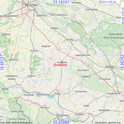
Grodków GPS coordinates[2]
50° 41' 54.096" North, 17° 23' 4.164" East
| Map corner | latitude | longitude |
|---|---|---|
| Upper-left | 51.14161°, | 16.68137° |
| Center: | 50.69836°, | 17.38449° |
| Lower-right: | 50.25088°, | 18.08762° |
| Map W x H: | 99×99 km | = 61.5×61.5mi |
| max Lat: | 54.83135° ⇑62.6% North |
| Grodków: | 50.69836° |
| min Lat: | ⇓37.4% South 49.21328° |
| min Long | Grodków | max Long |
| 14.20249° | 17.38449° | 24.03723° |
| W 19.3%⇐ | ⇒80.7% E |
Elevation
Elevation of Grodków is 172 m = 564 ft, and this is 19.4 m = 64 ft below average elevation for this country.
| Max E: |
974 m = 3196 ft | 49.8% |
| Avg. | 191.4 m = 628 ft | |
| Grodków | 172 m = 564 ft | |
Min E: |
-3 m = -10 ft | 50.2% |
See also: Poland elevation on elevation.city.
Geographical zone
Grodków is located in North temperate zone (between Tropic of Cancer and the Arctic Circle). Distance of this North polar circle is 1764 km =1096.1 mi to North.| Distance of | km | miles | from Grodków |
|---|---|---|---|
| North Pole | 4369.9 | 2715.3 | to North |
| Arctic Circle | 1764 | 1096.1 | to North |
| Tropic Cancer | 3031.2 | 1883.5 | to South |
| Equator | 5637.1 | 3502.7 | to South |


Nearby cities:
15 places around Grodków: (largest is in red/bold)
• Chróścina
8.4 km =5.2 mi,  187°
187°
• Krzyżowice
13.4 km =8.3 mi,  24°
24°
• Lewin Brzeski
17.3 km =10.7 mi,  71°
71°
• Michałow
10.1 km =6.3 mi,  59°
59°
• Niemodlin
17.7 km =11 mi,  110°
110°
• Olszanka
12.6 km =7.8 mi,  31°
31°
• Pakosławice
17.1 km =10.6 mi,  184°
184°
• Pogorzela
12.5 km =7.8 mi,  37°
37°
• Prusinowice
18 km =11.2 mi,  174°
174°
• Przeworno
15.5 km =9.6 mi,  265°
265°
• Sidzina
14.6 km =9.1 mi,  161°
161°
• Skarbimierz Osiedle
16.6 km =10.3 mi,  8°
8°
• Skoroszyce
11.3 km =7 mi, 180°
• Wiązów
18.2 km =11.3 mi,  315°
315°
• Łosiów
16.4 km =10.2 mi,  51°
51°
Sources, notices
• [Note1] Compared only with cities in Poland existing in our database
• [Src1] Map data: © OpenStreetMap contributors (CC-BY-SA)
• [Src2] Other city data from geonames.org with taken over terms of usage.
• [Src3] Geographical zone / Annual Mean Temperature by Robert A. Rohde @ Wikipedia
