Popów geodata
Popów (Silesia) is a seat of a third-order administrative division; located in Poland in Europe/Warsaw (GMT+2) time zone. In our database, there are 3649 cities with bigger population. Compared to other cities in Poland, 54.2% of cities are located further ↑North; 61.3% of cities are located further →East and 64.8% of cities have lower elevation than Popów. Note1


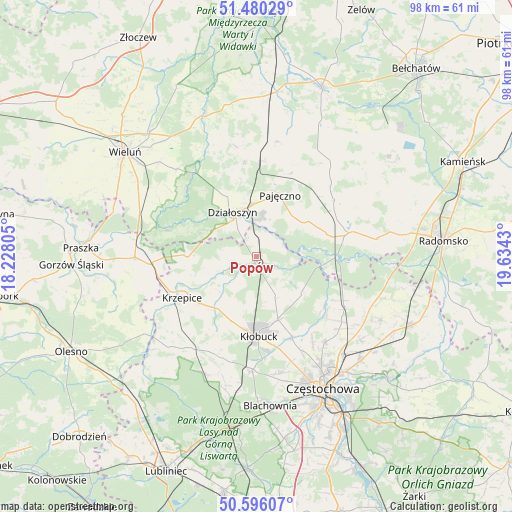
Popów GPS coordinates[2]
51° 2' 25.044" North, 18° 55' 52.212" East
| Map corner | latitude | longitude |
|---|---|---|
| Upper-left | 51.48029°, | 18.22805° |
| Center: | 51.04029°, | 18.93117° |
| Lower-right: | 50.59607°, | 19.6343° |
| Map W x H: | 98.3×98.3 km | = 61.1×61.1mi |
| max Lat: | 54.83135° ⇑54.2% North |
| Popów: | 51.04029° |
| min Lat: | ⇓45.8% South 49.21328° |
| min Long | Popów | max Long |
| 14.20249° | 18.93117° | 24.03723° |
| W 38.7%⇐ | ⇒61.3% E |
Elevation
Elevation of Popów is 214 m = 702 ft, and this is 22.6 m = 74 ft above average elevation for this country.
| Max E: |
974 m = 3196 ft | 35.2% |
| Popów | 214 m 702 ft | |
| Avg. | 191.4 m = 628 ft | |
Min E: |
-3 m = -10 ft | 64.8% |
See also: Poland elevation on elevation.city.
Geographical zone
Popów is located in North temperate zone (between Tropic of Cancer and the Arctic Circle). Distance of this North polar circle is 1726 km =1072.5 mi to North.| Distance of | km | miles | from Popów |
|---|---|---|---|
| North Pole | 4331.9 | 2691.7 | to North |
| Arctic Circle | 1726 | 1072.5 | to North |
| Tropic Cancer | 3069.2 | 1907.1 | to South |
| Equator | 5675.1 | 3526.3 | to South |


Nearby cities:
15 places around Popów: (largest is in red/bold)
• Działoszyn
9.7 km =6 mi,  331°
331°
• Kamyk
16.8 km =10.4 mi,  156°
156°
• Krzepice
16.1 km =10 mi,  241°
241°
• Kłobuck
15.5 km =9.6 mi,  178°
178°
• Lipie
9.9 km =6.2 mi,  251°
251°
• Miedzno
8.6 km =5.3 mi, 155°
• Nowa Brzeźnica
18.2 km =11.3 mi,  75°
75°
• Opatów
12.2 km =7.6 mi,  219°
219°
• Ostrowy nad Okszą
11 km =6.8 mi,  128°
128°
• Pajęczno
12.4 km =7.7 mi,  21°
21°
• Siemkowice
18.1 km =11.2 mi,  352°
352°
• Strzelce Wielkie
18.6 km =11.6 mi,  53°
53°
• Truskolasy
20.6 km =12.8 mi,  200°
200°
• Zawady
2.1 km =1.3 mi, 203°
• Łobodno
12.9 km =8 mi, 161°
Sources, notices
• [Note1] Compared only with cities in Poland existing in our database
• [Src1] Map data: © OpenStreetMap contributors (CC-BY-SA)
• [Src2] Other city data from geonames.org with taken over terms of usage.
• [Src3] Geographical zone / Annual Mean Temperature by Robert A. Rohde @ Wikipedia
