Działoszyn geodata
Działoszyn (Łódź Voivodeship) is a populated place; located in Poland in Europe/Warsaw (GMT+2) time zone. With population of 6,222 people, there are 585 cities with bigger population in this country. Compared to other cities in Poland, 51.9% of cities are located further ↑North; 62.4% of cities are located further →East and 53.8% of cities have lower elevation than Działoszyn. Note1
Administrative division(s):
- Level 1: Łódź Voivodeship
- Level 2: Powiat pajęczański
- Level 3: Działoszyn


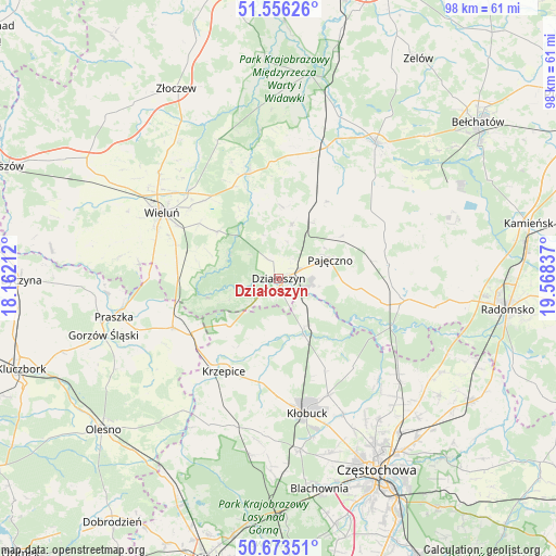
Działoszyn GPS coordinates[2]
51° 7' 1.164" North, 18° 51' 54.864" East
| Map corner | latitude | longitude |
|---|---|---|
| Upper-left | 51.55626°, | 18.16212° |
| Center: | 51.11699°, | 18.86524° |
| Lower-right: | 50.67351°, | 19.56837° |
| Map W x H: | 98.2×98.2 km | = 61×61mi |
| max Lat: | 54.83135° ⇑51.9% North |
| Działoszyn: | 51.11699° |
| min Lat: | ⇓48.1% South 49.21328° |
| min Long | Działoszyn | max Long |
| 14.20249° | 18.86524° | 24.03723° |
| W 37.6%⇐ | ⇒62.4% E |
Elevation
Elevation of Działoszyn is 182 m = 597 ft, and this is 9.4 m = 31 ft below average elevation for this country.
| Max E: |
974 m = 3196 ft | 46.2% |
| Avg. | 191.4 m = 628 ft | |
| Działoszyn | 182 m = 597 ft | |
Min E: |
-3 m = -10 ft | 53.8% |
See also: Poland elevation on elevation.city.
Geographical zone
Działoszyn is located in North temperate zone (between Tropic of Cancer and the Arctic Circle). Distance of this North polar circle is 1717.5 km =1067.2 mi to North.| Distance of | km | miles | from Działoszyn |
|---|---|---|---|
| North Pole | 4323.4 | 2686.4 | to North |
| Arctic Circle | 1717.5 | 1067.2 | to North |
| Tropic Cancer | 3077.8 | 1912.5 | to South |
| Equator | 5683.7 | 3531.7 | to South |


Nearby cities:
15 places around Działoszyn: (largest is in red/bold)
• Kiełczygłów
15.8 km =9.8 mi,  31°
31°
• Krzepice
18.9 km =11.7 mi,  210°
210°
• Lipie
12.6 km =7.8 mi,  202°
202°
• Lipnik
13 km =8.1 mi,  1°
1°
• Miedzno
18.2 km =11.3 mi,  153°
153°
• Opatów
18.2 km =11.3 mi,  190°
190°
• Osjaków
19.9 km =12.4 mi,  345°
345°
• Pajęczno
9.6 km =6 mi,  71°
71°
• Popów
9.7 km =6 mi, 151°
• Pątnów
17.6 km =10.9 mi,  279°
279°
• Rząśnia
17 km =10.6 mi,  47°
47°
• Siemkowice
9.7 km =6 mi,  13°
13°
• Strzelce Wielkie
19.7 km =12.2 mi,  82°
82°
• Wierzchlas
17 km =10.6 mi,  304°
304°
• Zawady
11.1 km =6.9 mi,  160°
160°
Sources, notices
• [Note1] Compared only with cities in Poland existing in our database
• [Src1] Map data: © OpenStreetMap contributors (CC-BY-SA)
• [Src2] Other city data from geonames.org with taken over terms of usage.
• [Src3] Geographical zone / Annual Mean Temperature by Robert A. Rohde @ Wikipedia
