Opatów geodata
Opatów (Silesia) is a seat of a third-order administrative division; located in Poland in Europe/Warsaw (GMT+2) time zone. With population of 1,213 people, there are 2154 cities with bigger population in this country. Compared to other cities in Poland, 56.3% of cities are located further ↑North; 63% of cities are located further →East and 69.1% of cities have lower elevation than Opatów. Note1


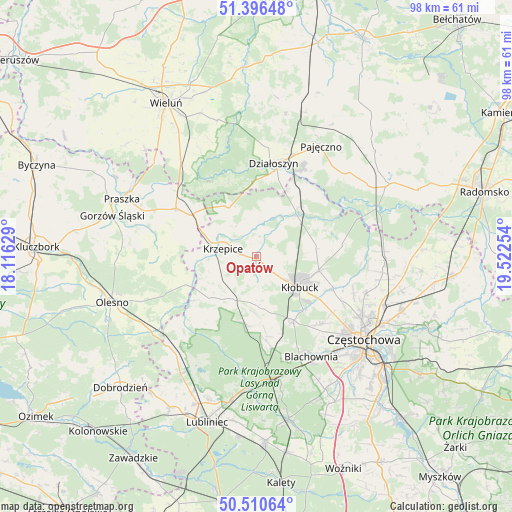
Opatów GPS coordinates[2]
50° 57' 20.412" North, 18° 49' 9.876" East
| Map corner | latitude | longitude |
|---|---|---|
| Upper-left | 51.39648°, | 18.11629° |
| Center: | 50.95567°, | 18.81941° |
| Lower-right: | 50.51064°, | 19.52254° |
| Map W x H: | 98.5×98.5 km | = 61.2×61.2mi |
| max Lat: | 54.83135° ⇑56.3% North |
| Opatów: | 50.95567° |
| min Lat: | ⇓43.7% South 49.21328° |
| min Long | Opatów | max Long |
| 14.20249° | 18.81941° | 24.03723° |
| W 37%⇐ | ⇒63% E |
Elevation
Elevation of Opatów is 226 m = 741 ft, and this is 34.6 m = 114 ft above average elevation for this country.
| Max E: |
974 m = 3196 ft | 30.9% |
| Opatów | 226 m 741 ft | |
| Avg. | 191.4 m = 628 ft | |
Min E: |
-3 m = -10 ft | 69.1% |
See also: Poland elevation on elevation.city.
Geographical zone
Opatów is located in North temperate zone (between Tropic of Cancer and the Arctic Circle). Distance of this North polar circle is 1735.4 km =1078.3 mi to North.| Distance of | km | miles | from Opatów |
|---|---|---|---|
| North Pole | 4341.3 | 2697.6 | to North |
| Arctic Circle | 1735.4 | 1078.3 | to North |
| Tropic Cancer | 3059.8 | 1901.3 | to South |
| Equator | 5665.7 | 3520.5 | to South |


Nearby cities:
15 places around Opatów: (largest is in red/bold)
• Kalej
17.6 km =10.9 mi,  138°
138°
• Kamyk
15.8 km =9.8 mi,  112°
112°
• Krzepice
6.6 km =4.1 mi,  284°
284°
• Kłobuck
10.2 km =6.3 mi,  126°
126°
• Lipie
6.5 km =4 mi,  345°
345°
• Miedzno
11.4 km =7.1 mi,  82°
82°
• Ostrowy nad Okszą
16.6 km =10.3 mi, 81°
• Panki
9.3 km =5.8 mi,  210°
210°
• Popów
12.2 km =7.6 mi,  39°
39°
• Przystajń
11.9 km =7.4 mi,  228°
228°
• Starokrzepice
11.7 km =7.3 mi,  266°
266°
• Truskolasy
9.9 km =6.2 mi,  176°
176°
• Wręczyca Wielka
14.1 km =8.8 mi,  149°
149°
• Zawady
10.3 km =6.4 mi, 43°
• Łobodno
12.3 km =7.6 mi,  102°
102°
Sources, notices
• [Note1] Compared only with cities in Poland existing in our database
• [Src1] Map data: © OpenStreetMap contributors (CC-BY-SA)
• [Src2] Other city data from geonames.org with taken over terms of usage.
• [Src3] Geographical zone / Annual Mean Temperature by Robert A. Rohde @ Wikipedia
