Lipie geodata
Lipie (Silesia) is a populated place; located in Poland in Europe/Warsaw (GMT+2) time zone. With population of 1,103 people, there are 2302 cities with bigger population in this country. Compared to other cities in Poland, 55.2% of cities are located further ↑North; 63.4% of cities are located further →East and 67.4% of cities have lower elevation than Lipie. Note1


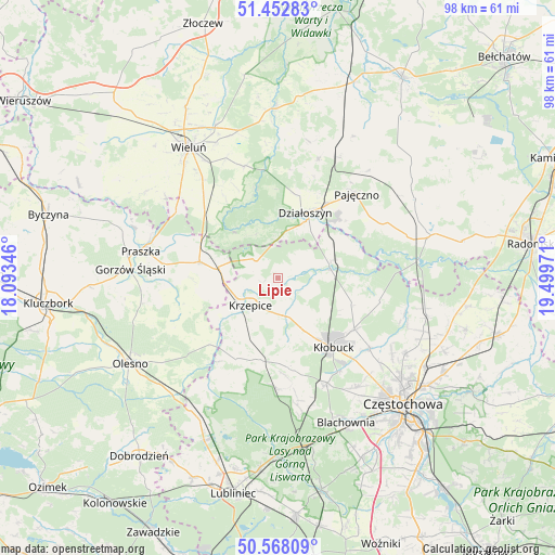
Lipie GPS coordinates[2]
51° 0' 45.252" North, 18° 47' 47.688" East
| Map corner | latitude | longitude |
|---|---|---|
| Upper-left | 51.45283°, | 18.09346° |
| Center: | 51.01257°, | 18.79658° |
| Lower-right: | 50.56809°, | 19.49971° |
| Map W x H: | 98.4×98.4 km | = 61.1×61.1mi |
| max Lat: | 54.83135° ⇑55.2% North |
| Lipie: | 51.01257° |
| min Lat: | ⇓44.8% South 49.21328° |
| min Long | Lipie | max Long |
| 14.20249° | 18.79658° | 24.03723° |
| W 36.6%⇐ | ⇒63.4% E |
Elevation
Elevation of Lipie is 221 m = 725 ft, and this is 29.6 m = 97 ft above average elevation for this country.
| Max E: |
974 m = 3196 ft | 32.6% |
| Lipie | 221 m 725 ft | |
| Avg. | 191.4 m = 628 ft | |
Min E: |
-3 m = -10 ft | 67.4% |
See also: Poland elevation on elevation.city.
Geographical zone
Lipie is located in North temperate zone (between Tropic of Cancer and the Arctic Circle). Distance of this North polar circle is 1729.1 km =1074.4 mi to North.| Distance of | km | miles | from Lipie |
|---|---|---|---|
| North Pole | 4335 | 2693.6 | to North |
| Arctic Circle | 1729.1 | 1074.4 | to North |
| Tropic Cancer | 3066.1 | 1905.2 | to South |
| Equator | 5672.1 | 3524.5 | to South |


Nearby cities:
15 places around Lipie: (largest is in red/bold)
• Dalachów
16.9 km =10.5 mi,  295°
295°
• Działoszyn
12.6 km =7.8 mi,  22°
22°
• Krzepice
6.7 km =4.2 mi,  225°
225°
• Kłobuck
15.8 km =9.8 mi,  141°
141°
• Miedzno
13.8 km =8.6 mi,  110°
110°
• Opatów
6.5 km =4 mi,  165°
165°
• Ostrowy nad Okszą
18.4 km =11.4 mi,  102°
102°
• Panki
14.7 km =9.1 mi,  192°
192°
• Popów
9.9 km =6.2 mi,  71°
71°
• Przystajń
16 km =9.9 mi,  207°
207°
• Rudniki
14.2 km =8.8 mi,  281°
281°
• Starokrzepice
12.3 km =7.6 mi, 234°
• Truskolasy
16.3 km =10.1 mi, 172°
• Zawady
8.7 km =5.4 mi,  82°
82°
• Łobodno
16.4 km =10.2 mi,  123°
123°
Sources, notices
• [Note1] Compared only with cities in Poland existing in our database
• [Src1] Map data: © OpenStreetMap contributors (CC-BY-SA)
• [Src2] Other city data from geonames.org with taken over terms of usage.
• [Src3] Geographical zone / Annual Mean Temperature by Robert A. Rohde @ Wikipedia
