Pajęczno geodata
Pajęczno (Łódź Voivodeship) is a seat of a third-order administrative division; located in Poland in Europe/Warsaw (GMT+2) time zone. With population of 6,731 people, there are 559 cities with bigger population in this country. Compared to other cities in Poland, 50.7% of cities are located further ↑North; 60.1% of cities are located further →East and 67.7% of cities have lower elevation than Pajęczno. Note1


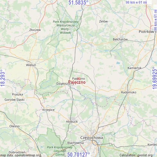
Pajęczno GPS coordinates[2]
51° 8' 40.164" North, 18° 59' 46.032" East
| Map corner | latitude | longitude |
|---|---|---|
| Upper-left | 51.5835°, | 18.293° |
| Center: | 51.14449°, | 18.99612° |
| Lower-right: | 50.70127°, | 19.69925° |
| Map W x H: | 98.1×98.1 km | = 61×61mi |
| max Lat: | 54.83135° ⇑50.7% North |
| Pajęczno: | 51.14449° |
| min Lat: | ⇓49.3% South 49.21328° |
| min Long | Pajęczno | max Long |
| 14.20249° | 18.99612° | 24.03723° |
| W 39.9%⇐ | ⇒60.1% E |
Elevation
Elevation of Pajęczno is 222 m = 728 ft, and this is 30.6 m = 100 ft above average elevation for this country.
| Max E: |
974 m = 3196 ft | 32.3% |
| Pajęczno | 222 m 728 ft | |
| Avg. | 191.4 m = 628 ft | |
Min E: |
-3 m = -10 ft | 67.7% |
See also: Poland elevation on elevation.city.
Geographical zone
Pajęczno is located in North temperate zone (between Tropic of Cancer and the Arctic Circle). Distance of this North polar circle is 1714.4 km =1065.3 mi to North.| Distance of | km | miles | from Pajęczno |
|---|---|---|---|
| North Pole | 4320.3 | 2684.5 | to North |
| Arctic Circle | 1714.4 | 1065.3 | to North |
| Tropic Cancer | 3080.8 | 1914.3 | to South |
| Equator | 5686.7 | 3533.6 | to South |


Nearby cities:
15 places around Pajęczno: (largest is in red/bold)
• Działoszyn
9.6 km =6 mi,  251°
251°
• Kiełczygłów
10.5 km =6.5 mi,  354°
354°
• Lipie
20.2 km =12.6 mi,  223°
223°
• Lipnik
13.3 km =8.3 mi,  318°
318°
• Miedzno
19.4 km =12.1 mi,  183°
183°
• Nowa Brzeźnica
14.8 km =9.2 mi,  118°
118°
• Osjaków
21.5 km =13.4 mi, 318°
• Ostrowy nad Okszą
18.9 km =11.7 mi,  167°
167°
• Popów
12.4 km =7.7 mi,  201°
201°
• Rusiec
20 km =12.4 mi,  357°
357°
• Rząśnia
9.1 km =5.7 mi,  21°
21°
• Siemkowice
9.3 km =5.8 mi,  313°
313°
• Strzelce Wielkie
10.4 km =6.5 mi,  93°
93°
• Sulmierzyce
14.6 km =9.1 mi,  72°
72°
• Zawady
14.5 km =9 mi, 201°
Sources, notices
• [Note1] Compared only with cities in Poland existing in our database
• [Src1] Map data: © OpenStreetMap contributors (CC-BY-SA)
• [Src2] Other city data from geonames.org with taken over terms of usage.
• [Src3] Geographical zone / Annual Mean Temperature by Robert A. Rohde @ Wikipedia
