Polkowice geodata
Polkowice (Lower Silesia) is a seat of a second-order administrative division; located in Poland in Europe/Warsaw (GMT+2) time zone. With population of 21,565 people, there are 230 cities with bigger population in this country. Compared to other cities in Poland, 56.4% of cities are located further ↓South; 92.1% of cities are located further →East and 52.6% of cities have lower elevation than Polkowice. Note1


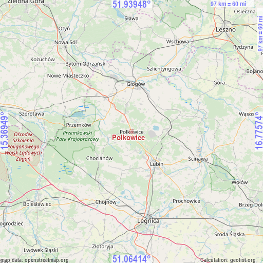
Polkowice GPS coordinates[2]
51° 30' 14.076" North, 16° 4' 21.396" East
| Map corner | latitude | longitude |
|---|---|---|
| Upper-left | 51.93948°, | 15.36949° |
| Center: | 51.50391°, | 16.07261° |
| Lower-right: | 51.06414°, | 16.77574° |
| Map W x H: | 97.3×97.3 km | = 60.5×60.5mi |
| max Lat: | 54.83135° ⇑43.6% North |
| Polkowice: | 51.50391° |
| min Lat: | ⇓56.4% South 49.21328° |
| min Long | Polkowice | max Long |
| 14.20249° | 16.07261° | 24.03723° |
| W 7.9%⇐ | ⇒92.1% E |
Elevation
Elevation of Polkowice is 179 m = 587 ft, and this is 12.4 m = 41 ft below average elevation for this country.
| Max E: |
974 m = 3196 ft | 47.4% |
| Avg. | 191.4 m = 628 ft | |
| Polkowice | 179 m = 587 ft | |
Min E: |
-3 m = -10 ft | 52.6% |
See also: Poland elevation on elevation.city.
Geographical zone
Polkowice is located in North temperate zone (between Tropic of Cancer and the Arctic Circle). Distance of this North polar circle is 1674.5 km =1040.5 mi to North.| Distance of | km | miles | from Polkowice |
|---|---|---|---|
| North Pole | 4280.4 | 2659.7 | to North |
| Arctic Circle | 1674.5 | 1040.5 | to North |
| Tropic Cancer | 3120.8 | 1939.2 | to South |
| Equator | 5726.7 | 3558.4 | to South |


Nearby cities:
15 places around Polkowice: (largest is in red/bold)
• Chocianów
15.2 km =9.4 mi,  231°
231°
• Gaworzyce
19.1 km =11.9 mi,  316°
316°
• Grębocice
12.4 km =7.7 mi,  31°
31°
• Głogów
17.8 km =11.1 mi,  2°
2°
• Jerzmanowa
10.4 km =6.5 mi,  349°
349°
• Kłobuczyn
15.8 km =9.8 mi, 321°
• Lubin
14.5 km =9 mi,  142°
142°
• Niegosławice
26.5 km =16.5 mi,  290°
290°
• Osiek
18.9 km =11.7 mi, 143°
• Przemków
19.4 km =12.1 mi,  277°
277°
• Radwanice
11.4 km =7.1 mi,  310°
310°
• Rudna
13.2 km =8.2 mi,  87°
87°
• Szlichtyngowa
26 km =16.2 mi, 27°
• Ścinawa
26.3 km =16.3 mi,  111°
111°
• Żukowice
19.8 km =12.3 mi,  341°
341°
Sources, notices
• [Note1] Compared only with cities in Poland existing in our database
• [Src1] Map data: © OpenStreetMap contributors (CC-BY-SA)
• [Src2] Other city data from geonames.org with taken over terms of usage.
• [Src3] Geographical zone / Annual Mean Temperature by Robert A. Rohde @ Wikipedia
