Lubin geodata
Lubin (Lower Silesia) is a seat of a second-order administrative division; located in Poland in Europe/Warsaw (GMT+2) time zone. With population of 77,532 people, there are 59 cities with bigger population in this country. Compared to other cities in Poland, 54.9% of cities are located further ↓South; 91.4% of cities are located further →East and 67.1% of cities have higher elevation than Lubin. Note1


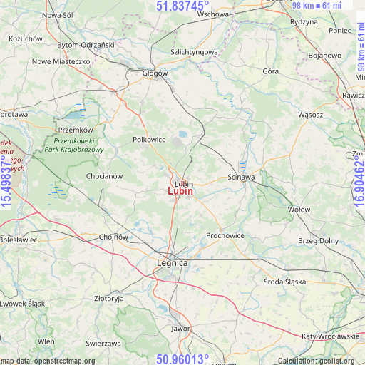
Lubin GPS coordinates[2]
51° 24' 3.204" North, 16° 12' 5.364" East
| Map corner | latitude | longitude |
|---|---|---|
| Upper-left | 51.83745°, | 15.49837° |
| Center: | 51.40089°, | 16.20149° |
| Lower-right: | 50.96013°, | 16.90462° |
| Map W x H: | 97.5×97.5 km | = 60.6×60.6mi |
| max Lat: | 54.83135° ⇑45.1% North |
| Lubin: | 51.40089° |
| min Lat: | ⇓54.9% South 49.21328° |
| min Long | Lubin | max Long |
| 14.20249° | 16.20149° | 24.03723° |
| W 8.6%⇐ | ⇒91.4% E |
Elevation
Elevation of Lubin is 128 m = 420 ft, and this is 63.4 m = 208 ft below average elevation for this country.
| Max E: |
974 m = 3196 ft | 67.1% |
| Avg. | 191.4 m = 628 ft | |
| Lubin | 128 m = 420 ft | |
Min E: |
-3 m = -10 ft | 32.9% |
See also: Lubin elevation on elevation.city.
Geographical zone
Lubin is located in North temperate zone (between Tropic of Cancer and the Arctic Circle). Distance of this North polar circle is 1685.9 km =1047.6 mi to North.| Distance of | km | miles | from Lubin |
|---|---|---|---|
| North Pole | 4291.8 | 2666.8 | to North |
| Arctic Circle | 1685.9 | 1047.6 | to North |
| Tropic Cancer | 3109.3 | 1932 | to South |
| Equator | 5715.2 | 3551.3 | to South |


Nearby cities:
15 places around Lubin: (largest is in red/bold)
• Chocianów
20.9 km =13 mi,  275°
275°
• Chojnów
23.2 km =14.4 mi,  232°
232°
• Grębocice
22.2 km =13.8 mi,  353°
353°
• Jemielno
27.4 km =17 mi,  59°
59°
• Jerzmanowa
24.3 km =15.1 mi,  333°
333°
• Kunice
20.1 km =12.5 mi,  170°
170°
• Legnica
21.4 km =13.3 mi,  187°
187°
• Lisowice
16.1 km =10 mi,  140°
140°
• Miłkowice
18.4 km =11.4 mi,  209°
209°
• Osiek
4.4 km =2.7 mi,  149°
149°
• Polkowice
14.5 km =9 mi,  322°
322°
• Prochowice
18.2 km =11.3 mi, 141°
• Radwanice
25.8 km =16 mi, 317°
• Rudna
12.9 km =8 mi,  19°
19°
• Ścinawa
15.6 km =9.7 mi,  83°
83°
Sources, notices
• [Note1] Compared only with cities in Poland existing in our database
• [Src1] Map data: © OpenStreetMap contributors (CC-BY-SA)
• [Src2] Other city data from geonames.org with taken over terms of usage.
• [Src3] Geographical zone / Annual Mean Temperature by Robert A. Rohde @ Wikipedia
