Ścinawa geodata
Ścinawa (Lower Silesia) is a populated place; located in Poland in Europe/Warsaw (GMT+2) time zone. With population of 5,863 people, there are 613 cities with bigger population in this country. Compared to other cities in Poland, 55.1% of cities are located further ↓South; 90% of cities are located further →East and 82.7% of cities have higher elevation than Ścinawa. Note1


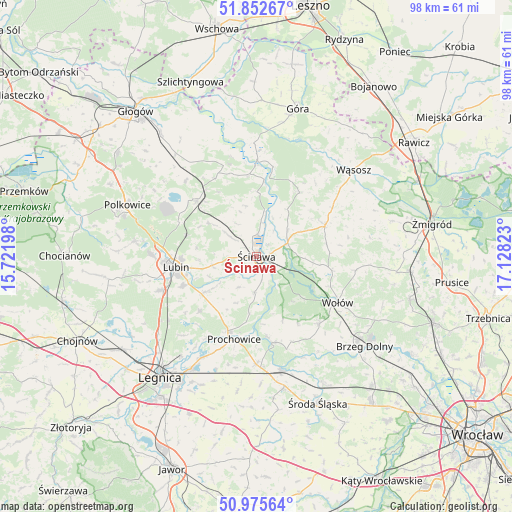
Ścinawa GPS coordinates[2]
51° 24' 58.536" North, 16° 25' 30.36" East
| Map corner | latitude | longitude |
|---|---|---|
| Upper-left | 51.85267°, | 15.72198° |
| Center: | 51.41626°, | 16.4251° |
| Lower-right: | 50.97564°, | 17.12823° |
| Map W x H: | 97.5×97.5 km | = 60.6×60.6mi |
| max Lat: | 54.83135° ⇑44.9% North |
| Ścinawa: | 51.41626° |
| min Lat: | ⇓55.1% South 49.21328° |
| min Long | Ścinawa | max Long |
| 14.20249° | 16.4251° | 24.03723° |
| W 10%⇐ | ⇒90% E |
Elevation
Elevation of Ścinawa is 94 m = 308 ft, and this is 97.4 m = 320 ft below average elevation for this country.
| Max E: |
974 m = 3196 ft | 82.7% |
| Avg. | 191.4 m = 628 ft | |
| Ścinawa | 94 m = 308 ft | |
Min E: |
-3 m = -10 ft | 17.3% |
See also: Poland elevation on elevation.city.
Geographical zone
Ścinawa is located in North temperate zone (between Tropic of Cancer and the Arctic Circle). Distance of this North polar circle is 1684.2 km =1046.5 mi to North.| Distance of | km | miles | from Ścinawa |
|---|---|---|---|
| North Pole | 4290.1 | 2665.7 | to North |
| Arctic Circle | 1684.2 | 1046.5 | to North |
| Tropic Cancer | 3111 | 1933.1 | to South |
| Equator | 5717 | 3552.4 | to South |


Nearby cities:
15 places around Ścinawa: (largest is in red/bold)
• Brzeg Dolny
25.3 km =15.7 mi,  129°
129°
• Grębocice
27 km =16.8 mi,  318°
318°
• Jemielno
14.5 km =9 mi,  34°
34°
• Kunice
24.8 km =15.4 mi,  209°
209°
• Lisowice
15.2 km =9.4 mi,  200°
200°
• Lubin
15.6 km =9.7 mi,  263°
263°
• Malczyce
22.3 km =13.9 mi,  167°
167°
• Osiek
14.4 km =8.9 mi,  247°
247°
• Polkowice
26.3 km =16.3 mi,  291°
291°
• Prochowice
16.5 km =10.3 mi,  194°
194°
• Rudna
15.3 km =9.5 mi,  312°
312°
• Szczepanów
27.5 km =17.1 mi,  152°
152°
• Wińsko
14.4 km =8.9 mi,  65°
65°
• Wołów
17.6 km =10.9 mi,  120°
120°
• Wąsosz
24.5 km =15.2 mi,  48°
48°
Sources, notices
• [Note1] Compared only with cities in Poland existing in our database
• [Src1] Map data: © OpenStreetMap contributors (CC-BY-SA)
• [Src2] Other city data from geonames.org with taken over terms of usage.
• [Src3] Geographical zone / Annual Mean Temperature by Robert A. Rohde @ Wikipedia
