Chocianów geodata
Chocianów (Lower Silesia) is a populated place; located in Poland in Europe/Warsaw (GMT+2) time zone. With population of 8,187 people, there are 501 cities with bigger population in this country. Compared to other cities in Poland, 55.2% of cities are located further ↓South; 93.1% of cities are located further →East and 59.5% of cities have higher elevation than Chocianów. Note1


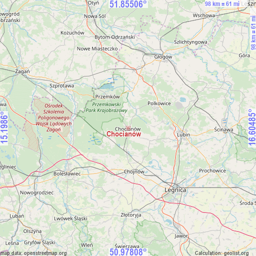
Chocianów GPS coordinates[2]
51° 25' 7.212" North, 15° 54' 6.192" East
| Map corner | latitude | longitude |
|---|---|---|
| Upper-left | 51.85506°, | 15.1986° |
| Center: | 51.41867°, | 15.90172° |
| Lower-right: | 50.97808°, | 16.60485° |
| Map W x H: | 97.5×97.5 km | = 60.6×60.6mi |
| max Lat: | 54.83135° ⇑44.8% North |
| Chocianów: | 51.41867° |
| min Lat: | ⇓55.2% South 49.21328° |
| min Long | Chocianów | max Long |
| 14.20249° | 15.90172° | 24.03723° |
| W 6.9%⇐ | ⇒93.1% E |
Elevation
Elevation of Chocianów is 148 m = 486 ft, and this is 43.4 m = 142 ft below average elevation for this country.
| Max E: |
974 m = 3196 ft | 59.5% |
| Avg. | 191.4 m = 628 ft | |
| Chocianów | 148 m = 486 ft | |
Min E: |
-3 m = -10 ft | 40.5% |
See also: Poland elevation on elevation.city.
Geographical zone
Chocianów is located in North temperate zone (between Tropic of Cancer and the Arctic Circle). Distance of this North polar circle is 1684 km =1046.4 mi to North.| Distance of | km | miles | from Chocianów |
|---|---|---|---|
| North Pole | 4289.8 | 2665.6 | to North |
| Arctic Circle | 1684 | 1046.4 | to North |
| Tropic Cancer | 3111.3 | 1933.3 | to South |
| Equator | 5717.2 | 3552.5 | to South |


Nearby cities:
15 places around Chocianów: (largest is in red/bold)
• Chojnów
16.3 km =10.1 mi,  171°
171°
• Gaworzyce
23.3 km =14.5 mi,  356°
356°
• Gromadka
11.5 km =7.1 mi,  235°
235°
• Jerzmanowa
22.1 km =13.7 mi,  26°
26°
• Krzywa
16.4 km =10.2 mi,  202°
202°
• Kłobuczyn
22 km =13.7 mi,  5°
5°
• Lubin
20.9 km =13 mi,  95°
95°
• Miłkowice
21.6 km =13.4 mi,  146°
146°
• Niegosławice
22.9 km =14.2 mi,  325°
325°
• Olszanica
24.6 km =15.3 mi, 196°
• Osiek
23.7 km =14.7 mi, 103°
• Polkowice
15.2 km =9.4 mi,  51°
51°
• Przemków
14 km =8.7 mi, 327°
• Radwanice
17.2 km =10.7 mi, 10°
• Zagrodno
25.4 km =15.8 mi,  185°
185°
Sources, notices
• [Note1] Compared only with cities in Poland existing in our database
• [Src1] Map data: © OpenStreetMap contributors (CC-BY-SA)
• [Src2] Other city data from geonames.org with taken over terms of usage.
• [Src3] Geographical zone / Annual Mean Temperature by Robert A. Rohde @ Wikipedia
