Tychowo geodata
Tychowo (West Pomerania) is a seat of a third-order administrative division; located in Poland in Europe/Warsaw (GMT+2) time zone. With population of 2,507 people, there are 1237 cities with bigger population in this country. Compared to other cities in Poland, 93.5% of cities are located further ↓South; 91% of cities are located further →East and 91.3% of cities have higher elevation than Tychowo. Note1


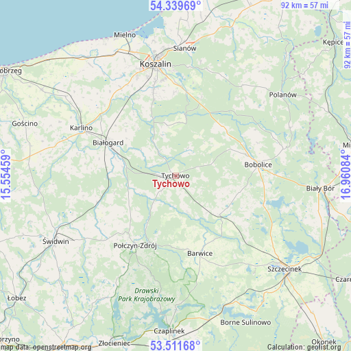
Tychowo GPS coordinates[2]
53° 55' 39.864" North, 16° 15' 27.756" East
| Map corner | latitude | longitude |
|---|---|---|
| Upper-left | 54.33969°, | 15.55459° |
| Center: | 53.92774°, | 16.25771° |
| Lower-right: | 53.51168°, | 16.96084° |
| Map W x H: | 92.1×92.1 km | = 57.2×57.2mi |
| max Lat: | 54.83135° ⇑6.5% North |
| Tychowo: | 53.92774° |
| min Lat: | ⇓93.5% South 49.21328° |
| min Long | Tychowo | max Long |
| 14.20249° | 16.25771° | 24.03723° |
| W 9%⇐ | ⇒91% E |
Elevation
Elevation of Tychowo is 69 m = 226 ft, and this is 122.4 m = 402 ft below average elevation for this country.
| Max E: |
974 m = 3196 ft | 91.3% |
| Avg. | 191.4 m = 628 ft | |
| Tychowo | 69 m = 226 ft | |
Min E: |
-3 m = -10 ft | 8.7% |
See also: Poland elevation on elevation.city.
Geographical zone
Tychowo is located in North temperate zone (between Tropic of Cancer and the Arctic Circle). Distance of this North polar circle is 1405 km =873 mi to North.| Distance of | km | miles | from Tychowo |
|---|---|---|---|
| North Pole | 4010.9 | 2492.3 | to North |
| Arctic Circle | 1405 | 873 | to North |
| Tropic Cancer | 3390.3 | 2106.6 | to South |
| Equator | 5996.2 | 3725.9 | to South |


Nearby cities:
15 places around Tychowo: (largest is in red/bold)
• Barwice
21.3 km =13.2 mi,  162°
162°
• Białogard
19.7 km =12.2 mi,  296°
296°
• Biesiekierz
26.9 km =16.7 mi,  327°
327°
• Bobolice
21.9 km =13.6 mi,  82°
82°
• Będzino
35.9 km =22.3 mi, 330°
• Grzmiąca
15.4 km =9.6 mi,  130°
130°
• Jamno
35.8 km =22.2 mi,  350°
350°
• Karlino
27.6 km =17.1 mi, 295°
• Koszalin
30.2 km =18.8 mi, 349°
• Manowo
22.2 km =13.8 mi,  7°
7°
• Polanów
35.1 km =21.8 mi,  52°
52°
• Połczyn-Zdrój
21.1 km =13.1 mi,  210°
210°
• Rąbino
21.6 km =13.4 mi,  251°
251°
• Sianów
33.3 km =20.7 mi,  3°
3°
• Świdwin
35.8 km =22.2 mi,  241°
241°
Sources, notices
• [Note1] Compared only with cities in Poland existing in our database
• [Src1] Map data: © OpenStreetMap contributors (CC-BY-SA)
• [Src2] Other city data from geonames.org with taken over terms of usage.
• [Src3] Geographical zone / Annual Mean Temperature by Robert A. Rohde @ Wikipedia
