Miastko geodata
Miastko (Pomerania) is a seat of a third-order administrative division; located in Poland in Europe/Warsaw (GMT+2) time zone. With population of 10,954 people, there are 419 cities with bigger population in this country. Compared to other cities in Poland, 94.2% of cities are located further ↓South; 85% of cities are located further →East and 68.2% of cities have higher elevation than Miastko. Note1


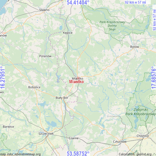
Miastko GPS coordinates[2]
54° 0' 10.188" North, 16° 58' 57.468" East
| Map corner | latitude | longitude |
|---|---|---|
| Upper-left | 54.41404°, | 16.27951° |
| Center: | 54.00283°, | 16.98263° |
| Lower-right: | 53.58752°, | 17.68576° |
| Map W x H: | 91.9×91.9 km | = 57.1×57.1mi |
| max Lat: | 54.83135° ⇑5.8% North |
| Miastko: | 54.00283° |
| min Lat: | ⇓94.2% South 49.21328° |
| min Long | Miastko | max Long |
| 14.20249° | 16.98263° | 24.03723° |
| W 15%⇐ | ⇒85% E |
Elevation
Elevation of Miastko is 125 m = 410 ft, and this is 66.4 m = 218 ft below average elevation for this country.
| Max E: |
974 m = 3196 ft | 68.2% |
| Avg. | 191.4 m = 628 ft | |
| Miastko | 125 m = 410 ft | |
Min E: |
-3 m = -10 ft | 31.8% |
See also: Poland elevation on elevation.city.
Geographical zone
Miastko is located in North temperate zone (between Tropic of Cancer and the Arctic Circle). Distance of this North polar circle is 1396.6 km =867.8 mi to North.| Distance of | km | miles | from Miastko |
|---|---|---|---|
| North Pole | 4002.5 | 2487 | to North |
| Arctic Circle | 1396.6 | 867.8 | to North |
| Tropic Cancer | 3398.6 | 2111.8 | to South |
| Equator | 6004.6 | 3731.1 | to South |


Nearby cities:
15 places around Miastko: (largest is in red/bold)
• Barcino
30.5 km =19 mi,  357°
357°
• Biały Bór
15.2 km =9.4 mi,  219°
219°
• Bobolice
26.3 km =16.3 mi,  258°
258°
• Borzytuchom
33.4 km =20.8 mi,  48°
48°
• Czarne
35.5 km =22.1 mi,  184°
184°
• Koczała
12.2 km =7.6 mi,  153°
153°
• Konarzyny
32.7 km =20.3 mi,  127°
127°
• Kołczygłowy
30.9 km =19.2 mi,  31°
31°
• Kępice
27.2 km =16.9 mi,  347°
347°
• Lipnica
27.7 km =17.2 mi,  91°
91°
• Polanów
23.3 km =14.5 mi,  303°
303°
• Przechlewo
28.8 km =17.9 mi,  142°
142°
• Rzeczenica
28.4 km =17.6 mi,  163°
163°
• Trzebielino
23 km =14.3 mi,  17°
17°
• Tuchomie
26.2 km =16.3 mi,  61°
61°
Sources, notices
• [Note1] Compared only with cities in Poland existing in our database
• [Src1] Map data: © OpenStreetMap contributors (CC-BY-SA)
• [Src2] Other city data from geonames.org with taken over terms of usage.
• [Src3] Geographical zone / Annual Mean Temperature by Robert A. Rohde @ Wikipedia
