Bobolice geodata
Bobolice (West Pomerania) is a seat of a third-order administrative division; located in Poland in Europe/Warsaw (GMT+2) time zone. With population of 4,365 people, there are 755 cities with bigger population in this country. Compared to other cities in Poland, 93.7% of cities are located further ↓South; 88.8% of cities are located further →East and 69.3% of cities have higher elevation than Bobolice. Note1


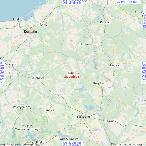
Bobolice GPS coordinates[2]
53° 57' 18.288" North, 16° 35' 20.148" East
| Map corner | latitude | longitude |
|---|---|---|
| Upper-left | 54.36676°, | 15.88581° |
| Center: | 53.95508°, | 16.58893° |
| Lower-right: | 53.53929°, | 17.29206° |
| Map W x H: | 92×92 km | = 57.2×57.2mi |
| max Lat: | 54.83135° ⇑6.3% North |
| Bobolice: | 53.95508° |
| min Lat: | ⇓93.7% South 49.21328° |
| min Long | Bobolice | max Long |
| 14.20249° | 16.58893° | 24.03723° |
| W 11.2%⇐ | ⇒88.8% E |
Elevation
Elevation of Bobolice is 122 m = 400 ft, and this is 69.4 m = 228 ft below average elevation for this country.
| Max E: |
974 m = 3196 ft | 69.3% |
| Avg. | 191.4 m = 628 ft | |
| Bobolice | 122 m = 400 ft | |
Min E: |
-3 m = -10 ft | 30.7% |
See also: Poland elevation on elevation.city.
Geographical zone
Bobolice is located in North temperate zone (between Tropic of Cancer and the Arctic Circle). Distance of this North polar circle is 1401.9 km =871.1 mi to North.| Distance of | km | miles | from Bobolice |
|---|---|---|---|
| North Pole | 4007.8 | 2490.3 | to North |
| Arctic Circle | 1401.9 | 871.1 | to North |
| Tropic Cancer | 3393.3 | 2108.5 | to South |
| Equator | 5999.2 | 3727.7 | to South |


Nearby cities:
15 places around Bobolice: (largest is in red/bold)
• Barwice
27.9 km =17.3 mi,  213°
213°
• Biały Bór
17.4 km =10.8 mi,  111°
111°
• Czarne
37.9 km =23.5 mi,  142°
142°
• Grzmiąca
16.5 km =10.3 mi,  217°
217°
• Koczała
31.7 km =19.7 mi,  100°
100°
• Kępice
37.4 km =23.2 mi,  31°
31°
• Manowo
26.7 km =16.6 mi,  315°
315°
• Miastko
26.3 km =16.3 mi,  78°
78°
• Ostrowiec
36.1 km =22.4 mi,  8°
8°
• Polanów
19.3 km =12 mi,  18°
18°
• Sianów
35.9 km =22.3 mi,  327°
327°
• Sitno
33.4 km =20.8 mi,  171°
171°
• Szczecinek
28.4 km =17.6 mi, 165°
• Tychowo
21.9 km =13.6 mi,  262°
262°
• Żółtnica
34.4 km =21.4 mi,  155°
155°
Sources, notices
• [Note1] Compared only with cities in Poland existing in our database
• [Src1] Map data: © OpenStreetMap contributors (CC-BY-SA)
• [Src2] Other city data from geonames.org with taken over terms of usage.
• [Src3] Geographical zone / Annual Mean Temperature by Robert A. Rohde @ Wikipedia
