Koczała geodata
Koczała (Pomerania) is a populated place; located in Poland in Europe/Warsaw (GMT+2) time zone. With population of 2,111 people, there are 1407 cities with bigger population in this country. Compared to other cities in Poland, 93.2% of cities are located further ↓South; 83.7% of cities are located further →East and 57.6% of cities have higher elevation than Koczała. Note1


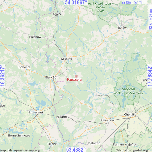
Koczała GPS coordinates[2]
53° 54' 16.164" North, 17° 3' 55.044" East
| Map corner | latitude | longitude |
|---|---|---|
| Upper-left | 54.31667°, | 16.36217° |
| Center: | 53.90449°, | 17.06529° |
| Lower-right: | 53.4882°, | 17.76842° |
| Map W x H: | 92.1×92.1 km | = 57.2×57.2mi |
| max Lat: | 54.83135° ⇑6.8% North |
| Koczała: | 53.90449° |
| min Lat: | ⇓93.2% South 49.21328° |
| min Long | Koczała | max Long |
| 14.20249° | 17.06529° | 24.03723° |
| W 16.3%⇐ | ⇒83.7% E |
Elevation
Elevation of Koczała is 152 m = 499 ft, and this is 39.4 m = 129 ft below average elevation for this country.
| Max E: |
974 m = 3196 ft | 57.6% |
| Avg. | 191.4 m = 628 ft | |
| Koczała | 152 m = 499 ft | |
Min E: |
-3 m = -10 ft | 42.4% |
See also: Poland elevation on elevation.city.
Geographical zone
Koczała is located in North temperate zone (between Tropic of Cancer and the Arctic Circle). Distance of this North polar circle is 1407.6 km =874.6 mi to North.| Distance of | km | miles | from Koczała |
|---|---|---|---|
| North Pole | 4013.4 | 2493.8 | to North |
| Arctic Circle | 1407.6 | 874.6 | to North |
| Tropic Cancer | 3387.7 | 2105 | to South |
| Equator | 5993.6 | 3724.2 | to South |


Nearby cities:
15 places around Koczała: (largest is in red/bold)
• Biały Bór
15.1 km =9.4 mi,  266°
266°
• Bobolice
31.7 km =19.7 mi,  280°
280°
• Czarne
25.9 km =16.1 mi,  198°
198°
• Człuchów
32.7 km =20.3 mi,  143°
143°
• Konarzyny
22.5 km =14 mi,  113°
113°
• Lipnica
24.6 km =15.3 mi,  65°
65°
• Miastko
12.2 km =7.6 mi,  333°
333°
• Polanów
34.5 km =21.4 mi,  313°
313°
• Przechlewo
17 km =10.6 mi,  133°
133°
• Rzeczenica
16.5 km =10.3 mi,  170°
170°
• Sitno
38 km =23.6 mi,  223°
223°
• Szczecinek
32.5 km =20.2 mi,  227°
227°
• Trzebielino
32.9 km =20.4 mi,  2°
2°
• Tuchomie
29.4 km =18.3 mi,  37°
37°
• Żółtnica
30.6 km =19 mi,  213°
213°
Sources, notices
• [Note1] Compared only with cities in Poland existing in our database
• [Src1] Map data: © OpenStreetMap contributors (CC-BY-SA)
• [Src2] Other city data from geonames.org with taken over terms of usage.
• [Src3] Geographical zone / Annual Mean Temperature by Robert A. Rohde @ Wikipedia
