Płock geodata
Płock (Mazovia) is a seat of a second-order administrative division; located in Poland in Europe/Warsaw (GMT+2) time zone. With population of 127,474 people, there are 35 cities with bigger population in this country. Compared to other cities in Poland, 77.1% of cities are located further ↓South; 52.9% of cities are located further ←West and 78.4% of cities have higher elevation than Płock. Note1


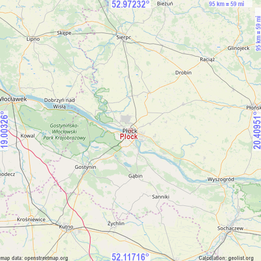
Płock GPS coordinates[2]
52° 32' 48.552" North, 19° 42' 22.968" East
| Map corner | latitude | longitude |
|---|---|---|
| Upper-left | 52.97232°, | 19.00326° |
| Center: | 52.54682°, | 19.70638° |
| Lower-right: | 52.11716°, | 20.40951° |
| Map W x H: | 95.1×95.1 km | = 59.1×59.1mi |
| max Lat: | 54.83135° ⇑22.9% North |
| Płock: | 52.54682° |
| min Lat: | ⇓77.1% South 49.21328° |
| min Long | Płock | max Long |
| 14.20249° | 19.70638° | 24.03723° |
| W 52.9%⇐ | ⇒47.1% E |
Elevation
Elevation of Płock is 103 m = 338 ft, and this is 88.4 m = 290 ft below average elevation for this country.
| Max E: |
974 m = 3196 ft | 78.4% |
| Avg. | 191.4 m = 628 ft | |
| Płock | 103 m = 338 ft | |
Min E: |
-3 m = -10 ft | 21.6% |
See also: Płock elevation on elevation.city.
Geographical zone
Płock is located in North temperate zone (between Tropic of Cancer and the Arctic Circle). Distance of this North polar circle is 1558.5 km =968.4 mi to North.| Distance of | km | miles | from Płock |
|---|---|---|---|
| North Pole | 4164.4 | 2587.6 | to North |
| Arctic Circle | 1558.5 | 968.4 | to North |
| Tropic Cancer | 3236.7 | 2011.2 | to South |
| Equator | 5842.7 | 3630.5 | to South |


Nearby cities:
15 places around Płock: (largest is in red/bold)
• Biała
7.5 km =4.7 mi,  329°
329°
• Bielsk
15.4 km =9.6 mi,  25°
25°
• Bodzanów
22.5 km =14 mi,  103°
103°
• Brudzeń Duży
19.3 km =12 mi,  314°
314°
• Gostynin
21.1 km =13.1 mi,  231°
231°
• Gozdowo
19.8 km =12.3 mi,  355°
355°
• Gąbin
16.6 km =10.3 mi,  173°
173°
• Maszewo Duże
6.4 km =4 mi, 305°
• Nowy Duninów
15.8 km =9.8 mi,  284°
284°
• Radzanowo
12.8 km =8 mi,  76°
76°
• Staroźreby
21.1 km =13.1 mi,  63°
63°
• Stary Barcik
20.5 km =12.7 mi,  154°
154°
• Słupno
10 km =6.2 mi,  117°
117°
• Łaziska
22.3 km =13.9 mi, 148°
• Łąck
11 km =6.8 mi,  215°
215°
Sources, notices
• [Note1] Compared only with cities in Poland existing in our database
• [Src1] Map data: © OpenStreetMap contributors (CC-BY-SA)
• [Src2] Other city data from geonames.org with taken over terms of usage.
• [Src3] Geographical zone / Annual Mean Temperature by Robert A. Rohde @ Wikipedia
