Biała geodata
Biała (Mazovia) is a seat of a third-order administrative division; located in Poland in Europe/Warsaw (GMT+2) time zone. With population of 613 people, there are 3245 cities with bigger population in this country. Compared to other cities in Poland, 78% of cities are located further ↓South; 51.8% of cities are located further ←West and 79.8% of cities have higher elevation than Biała. Note1


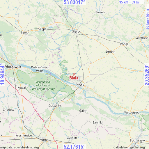
Biała GPS coordinates[2]
52° 36' 18.864" North, 19° 38' 58.416" East
| Map corner | latitude | longitude |
|---|---|---|
| Upper-left | 53.03017°, | 18.94644° |
| Center: | 52.60524°, | 19.64956° |
| Lower-right: | 52.17615°, | 20.35269° |
| Map W x H: | 95×95 km | = 59×59mi |
| max Lat: | 54.83135° ⇑22% North |
| Biała: | 52.60524° |
| min Lat: | ⇓78% South 49.21328° |
| min Long | Biała | max Long |
| 14.20249° | 19.64956° | 24.03723° |
| W 51.8%⇐ | ⇒48.2% E |
Elevation
Elevation of Biała is 100 m = 328 ft, and this is 91.4 m = 300 ft below average elevation for this country.
| Max E: |
974 m = 3196 ft | 79.8% |
| Avg. | 191.4 m = 628 ft | |
| Biała | 100 m = 328 ft | |
Min E: |
-3 m = -10 ft | 20.2% |
See also: Poland elevation on elevation.city.
Geographical zone
Biała is located in North temperate zone (between Tropic of Cancer and the Arctic Circle). Distance of this North polar circle is 1552 km =964.4 mi to North.| Distance of | km | miles | from Biała |
|---|---|---|---|
| North Pole | 4157.9 | 2583.6 | to North |
| Arctic Circle | 1552 | 964.4 | to North |
| Tropic Cancer | 3243.2 | 2015.2 | to South |
| Equator | 5849.2 | 3634.5 | to South |


Nearby cities:
15 places around Biała: (largest is in red/bold)
• Bielsk
12.8 km =8 mi,  54°
54°
• Brudzeń Duży
12.1 km =7.5 mi,  305°
305°
• Dobrzyń nad Wisłą
22.6 km =14 mi,  279°
279°
• Gostynin
23.3 km =14.5 mi,  212°
212°
• Gozdowo
13.5 km =8.4 mi,  10°
10°
• Gąbin
23.7 km =14.7 mi,  165°
165°
• Maszewo Duże
3.1 km =1.9 mi, 206°
• Mochowo
18.9 km =11.7 mi,  340°
340°
• Nowy Duninów
11.7 km =7.3 mi,  257°
257°
• Płock
7.5 km =4.7 mi,  149°
149°
• Radzanowo
16.7 km =10.4 mi,  102°
102°
• Staroźreby
22.9 km =14.2 mi,  82°
82°
• Słupno
16.8 km =10.4 mi,  131°
131°
• Tłuchowo
20.1 km =12.5 mi,  321°
321°
• Łąck
15.7 km =9.8 mi,  189°
189°
Sources, notices
• [Note1] Compared only with cities in Poland existing in our database
• [Src1] Map data: © OpenStreetMap contributors (CC-BY-SA)
• [Src2] Other city data from geonames.org with taken over terms of usage.
• [Src3] Geographical zone / Annual Mean Temperature by Robert A. Rohde @ Wikipedia
