Maszewo Duże geodata
Maszewo Duże (Mazovia) is a populated place; located in Poland in Europe/Warsaw (GMT+2) time zone. With population of 1,332 people, there are 2032 cities with bigger population in this country. Compared to other cities in Poland, 77.6% of cities are located further ↓South; 51.4% of cities are located further ←West and 75.8% of cities have higher elevation than Maszewo Duże. Note1


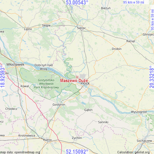
Maszewo Duże GPS coordinates[2]
52° 34' 48.936" North, 19° 37' 44.58" East
| Map corner | latitude | longitude |
|---|---|---|
| Upper-left | 53.00543°, | 18.92593° |
| Center: | 52.58026°, | 19.62905° |
| Lower-right: | 52.15092°, | 20.33218° |
| Map W x H: | 95×95 km | = 59×59mi |
| max Lat: | 54.83135° ⇑22.4% North |
| Maszewo Duże: | 52.58026° |
| min Lat: | ⇓77.6% South 49.21328° |
| min Long | Maszewo Duże | max Long |
| 14.20249° | 19.62905° | 24.03723° |
| W 51.4%⇐ | ⇒48.6% E |
Elevation
Elevation of Maszewo Duże is 109 m = 358 ft, and this is 82.4 m = 270 ft below average elevation for this country.
| Max E: |
974 m = 3196 ft | 75.8% |
| Avg. | 191.4 m = 628 ft | |
| Maszewo Duże | 109 m = 358 ft | |
Min E: |
-3 m = -10 ft | 24.2% |
See also: Poland elevation on elevation.city.
Geographical zone
Maszewo Duże is located in North temperate zone (between Tropic of Cancer and the Arctic Circle). Distance of this North polar circle is 1554.8 km =966.1 mi to North.| Distance of | km | miles | from Maszewo Duże |
|---|---|---|---|
| North Pole | 4160.7 | 2585.3 | to North |
| Arctic Circle | 1554.8 | 966.1 | to North |
| Tropic Cancer | 3240.5 | 2013.6 | to South |
| Equator | 5846.4 | 3632.8 | to South |


Nearby cities:
15 places around Maszewo Duże: (largest is in red/bold)
• Biała
3.1 km =1.9 mi,  26°
26°
• Bielsk
15.6 km =9.7 mi,  49°
49°
• Brudzeń Duży
13 km =8.1 mi,  319°
319°
• Dobrzyń nad Wisłą
21.9 km =13.6 mi,  287°
287°
• Gostynin
20.2 km =12.6 mi,  213°
213°
• Gozdowo
16.5 km =10.3 mi,  13°
13°
• Gąbin
21.4 km =13.3 mi,  160°
160°
• Mochowo
21.2 km =13.2 mi,  346°
346°
• Nowy Duninów
10.1 km =6.3 mi,  271°
271°
• Płock
6.4 km =4 mi,  125°
125°
• Radzanowo
17.7 km =11 mi,  92°
92°
• Staroźreby
24.8 km =15.4 mi,  76°
76°
• Słupno
16.3 km =10.1 mi,  120°
120°
• Tłuchowo
21.6 km =13.4 mi,  329°
329°
• Łąck
12.7 km =7.9 mi,  185°
185°
Sources, notices
• [Note1] Compared only with cities in Poland existing in our database
• [Src1] Map data: © OpenStreetMap contributors (CC-BY-SA)
• [Src2] Other city data from geonames.org with taken over terms of usage.
• [Src3] Geographical zone / Annual Mean Temperature by Robert A. Rohde @ Wikipedia
