Gostynin geodata
Gostynin (Mazovia) is a seat of a second-order administrative division; located in Poland in Europe/Warsaw (GMT+2) time zone. With population of 18,976 people, there are 255 cities with bigger population in this country. Compared to other cities in Poland, 75.2% of cities are located further ↓South; 51.7% of cities are located further →East and 85.2% of cities have higher elevation than Gostynin. Note1


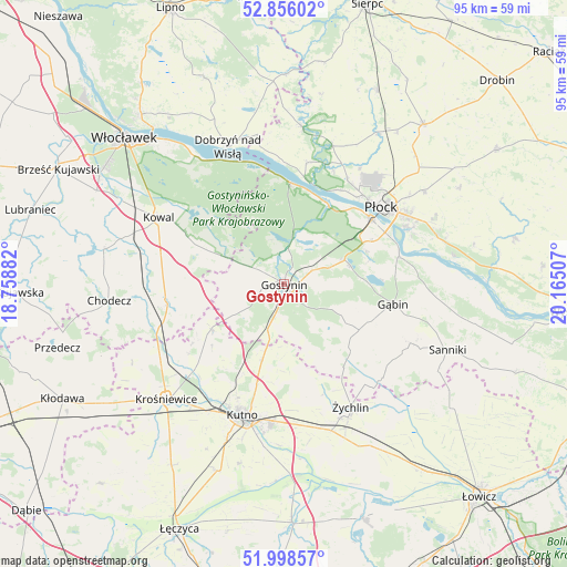
Gostynin GPS coordinates[2]
52° 25' 45.768" North, 19° 27' 42.984" East
| Map corner | latitude | longitude |
|---|---|---|
| Upper-left | 52.85602°, | 18.75882° |
| Center: | 52.42938°, | 19.46194° |
| Lower-right: | 51.99857°, | 20.16507° |
| Map W x H: | 95.3×95.3 km | = 59.2×59.2mi |
| max Lat: | 54.83135° ⇑24.8% North |
| Gostynin: | 52.42938° |
| min Lat: | ⇓75.2% South 49.21328° |
| min Long | Gostynin | max Long |
| 14.20249° | 19.46194° | 24.03723° |
| W 48.3%⇐ | ⇒51.7% E |
Elevation
Elevation of Gostynin is 89 m = 292 ft, and this is 102.4 m = 336 ft below average elevation for this country.
| Max E: |
974 m = 3196 ft | 85.2% |
| Avg. | 191.4 m = 628 ft | |
| Gostynin | 89 m = 292 ft | |
Min E: |
-3 m = -10 ft | 14.8% |
See also: Poland elevation on elevation.city.
Geographical zone
Gostynin is located in North temperate zone (between Tropic of Cancer and the Arctic Circle). Distance of this North polar circle is 1571.6 km =976.5 mi to North.| Distance of | km | miles | from Gostynin |
|---|---|---|---|
| North Pole | 4177.5 | 2595.8 | to North |
| Arctic Circle | 1571.6 | 976.5 | to North |
| Tropic Cancer | 3223.7 | 2003.1 | to South |
| Equator | 5829.6 | 3622.3 | to South |


Nearby cities:
15 places around Gostynin: (largest is in red/bold)
• Baruchowo
15.2 km =9.4 mi,  298°
298°
• Biała
23.3 km =14.5 mi,  32°
32°
• Gąbin
18.8 km =11.7 mi,  100°
100°
• Kaliska
23.3 km =14.5 mi,  264°
264°
• Kutno
23.1 km =14.4 mi,  196°
196°
• Lubień Kujawski
20.3 km =12.6 mi, 262°
• Maszewo Duże
20.2 km =12.6 mi, 33°
• Nowe Ostrowy
23.1 km =14.4 mi,  232°
232°
• Nowy Duninów
17.1 km =10.6 mi,  4°
4°
• Oporów
19.6 km =12.2 mi,  159°
159°
• Pacyna
21.9 km =13.6 mi,  129°
129°
• Płock
21.1 km =13.1 mi,  51°
51°
• Strzelce
13.3 km =8.3 mi, 196°
• Łanięta
14.4 km =8.9 mi,  238°
238°
• Łąck
10.9 km =6.8 mi,  67°
67°
Sources, notices
• [Note1] Compared only with cities in Poland existing in our database
• [Src1] Map data: © OpenStreetMap contributors (CC-BY-SA)
• [Src2] Other city data from geonames.org with taken over terms of usage.
• [Src3] Geographical zone / Annual Mean Temperature by Robert A. Rohde @ Wikipedia
