Radzanowo geodata
Radzanowo (Mazovia) is a seat of a third-order administrative division; located in Poland in Europe/Warsaw (GMT+2) time zone. With population of 1,186 people, there are 2228 cities with bigger population in this country. Compared to other cities in Poland, 77.5% of cities are located further ↓South; 56.8% of cities are located further ←West and 62.7% of cities have higher elevation than Radzanowo. Note1


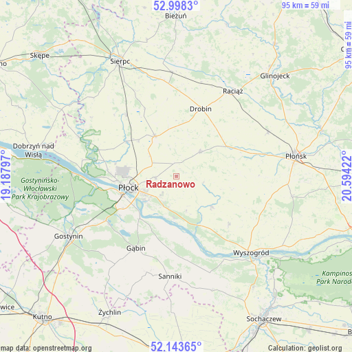
Radzanowo GPS coordinates[2]
52° 34' 23.016" North, 19° 53' 27.924" East
| Map corner | latitude | longitude |
|---|---|---|
| Upper-left | 52.9983°, | 19.18797° |
| Center: | 52.57306°, | 19.89109° |
| Lower-right: | 52.14365°, | 20.59422° |
| Map W x H: | 95×95 km | = 59×59mi |
| max Lat: | 54.83135° ⇑22.5% North |
| Radzanowo: | 52.57306° |
| min Lat: | ⇓77.5% South 49.21328° |
| min Long | Radzanowo | max Long |
| 14.20249° | 19.89109° | 24.03723° |
| W 56.8%⇐ | ⇒43.2% E |
Elevation
Elevation of Radzanowo is 140 m = 459 ft, and this is 51.4 m = 169 ft below average elevation for this country.
| Max E: |
974 m = 3196 ft | 62.7% |
| Avg. | 191.4 m = 628 ft | |
| Radzanowo | 140 m = 459 ft | |
Min E: |
-3 m = -10 ft | 37.3% |
See also: Poland elevation on elevation.city.
Geographical zone
Radzanowo is located in North temperate zone (between Tropic of Cancer and the Arctic Circle). Distance of this North polar circle is 1555.6 km =966.6 mi to North.| Distance of | km | miles | from Radzanowo |
|---|---|---|---|
| North Pole | 4161.5 | 2585.8 | to North |
| Arctic Circle | 1555.6 | 966.6 | to North |
| Tropic Cancer | 3239.7 | 2013.1 | to South |
| Equator | 5845.6 | 3632.3 | to South |


Nearby cities:
15 places around Radzanowo: (largest is in red/bold)
• Biała
16.7 km =10.4 mi,  282°
282°
• Bielsk
12.4 km =7.7 mi,  332°
332°
• Bodzanów
12.4 km =7.7 mi,  130°
130°
• Bulkowo
15.8 km =9.8 mi,  103°
103°
• Drobin
19.5 km =12.1 mi,  19°
19°
• Gozdowo
21.8 km =13.5 mi,  320°
320°
• Gąbin
22.1 km =13.7 mi,  208°
208°
• Maszewo Duże
17.7 km =11 mi,  272°
272°
• Mała Wieś
19.2 km =11.9 mi, 131°
• Płock
12.8 km =8 mi,  256°
256°
• Staroźreby
9.2 km =5.7 mi,  43°
43°
• Stary Barcik
21.9 km =13.6 mi,  190°
190°
• Słupno
8.3 km =5.2 mi, 205°
• Łaziska
21.9 km =13.6 mi,  182°
182°
• Łąck
22.3 km =13.9 mi,  237°
237°
Sources, notices
• [Note1] Compared only with cities in Poland existing in our database
• [Src1] Map data: © OpenStreetMap contributors (CC-BY-SA)
• [Src2] Other city data from geonames.org with taken over terms of usage.
• [Src3] Geographical zone / Annual Mean Temperature by Robert A. Rohde @ Wikipedia
