Bielsk geodata
Bielsk (Mazovia) is a seat of a third-order administrative division; located in Poland in Europe/Warsaw (GMT+1) time zone. With population of 2,600 people, there are 1204 cities with bigger population in this country. Compared to other cities in Poland, 78.9% of cities are located further ↓South; 55% of cities are located further ←West and 64.7% of cities have higher elevation than Bielsk. Note1


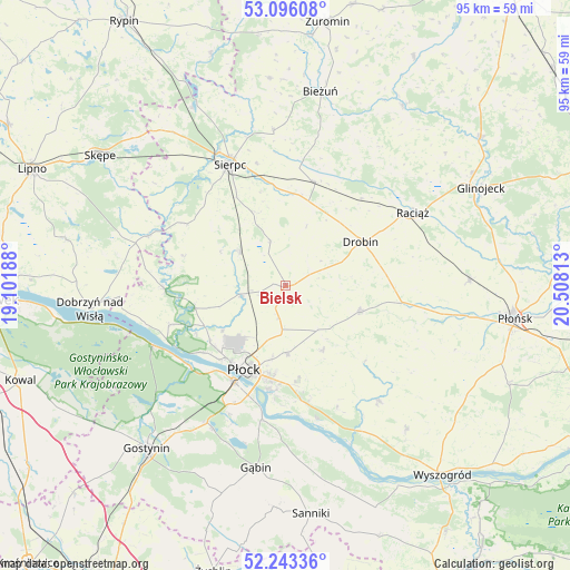
Bielsk GPS coordinates[2]
52° 40' 18.48" North, 19° 48' 18" East
| Map corner | latitude | longitude |
|---|---|---|
| Upper-left | 53.09608°, | 19.10188° |
| Center: | 52.6718°, | 19.805° |
| Lower-right: | 52.24336°, | 20.50813° |
| Map W x H: | 94.8×94.8 km | = 58.9×58.9mi |
| max Lat: | 54.83135° ⇑21.1% North |
| Bielsk: | 52.6718° |
| min Lat: | ⇓78.9% South 49.21328° |
| min Long | Bielsk | max Long |
| 14.20249° | 19.805° | 24.03723° |
| W 55%⇐ | ⇒45% E |
Elevation
Elevation of Bielsk is 134 m = 440 ft, and this is 57.4 m = 188 ft below average elevation for this country.
| Max E: |
974 m = 3196 ft | 64.7% |
| Avg. | 191.4 m = 628 ft | |
| Bielsk | 134 m = 440 ft | |
Min E: |
-3 m = -10 ft | 35.3% |
See also: Poland elevation on elevation.city.
Geographical zone
Bielsk is located in North temperate zone (between Tropic of Cancer and the Arctic Circle). Distance of this North polar circle is 1544.6 km =959.8 mi to North.| Distance of | km | miles | from Bielsk |
|---|---|---|---|
| North Pole | 4150.5 | 2579 | to North |
| Arctic Circle | 1544.6 | 959.8 | to North |
| Tropic Cancer | 3250.6 | 2019.8 | to South |
| Equator | 5856.6 | 3639.1 | to South |


Nearby cities:
15 places around Bielsk: (largest is in red/bold)
• Biała
12.8 km =8 mi,  234°
234°
• Brudzeń Duży
20.3 km =12.6 mi,  269°
269°
• Drobin
14.4 km =8.9 mi,  59°
59°
• Gozdowo
10 km =6.2 mi,  305°
305°
• Maszewo Duże
15.6 km =9.7 mi, 229°
• Mochowo
19.8 km =12.3 mi,  301°
301°
• Nowy Duninów
24.1 km =15 mi,  245°
245°
• Płock
15.4 km =9.6 mi,  205°
205°
• Raciąż
24.3 km =15.1 mi, 59°
• Radzanowo
12.4 km =7.7 mi,  152°
152°
• Sierpc
22.5 km =14 mi,  336°
336°
• Staroźreby
12.9 km =8 mi,  109°
109°
• Słupno
18.6 km =11.6 mi,  173°
173°
• Tłuchowo
24.3 km =15.1 mi,  290°
290°
• Zawidz
17.9 km =11.1 mi,  14°
14°
Sources, notices
• [Note1] Compared only with cities in Poland existing in our database
• [Src1] Map data: © OpenStreetMap contributors (CC-BY-SA)
• [Src2] Other city data from geonames.org with taken over terms of usage.
• [Src3] Geographical zone / Annual Mean Temperature by Robert A. Rohde @ Wikipedia
