Pcim geodata
Pcim (Lesser Poland) is a seat of a third-order administrative division; located in Poland in Europe/Warsaw (GMT+2) time zone. With population of 4,900 people, there are 696 cities with bigger population in this country. Compared to other cities in Poland, 93% of cities are located further ↑North; 57.9% of cities are located further ←West and 89.8% of cities have lower elevation than Pcim. Note1


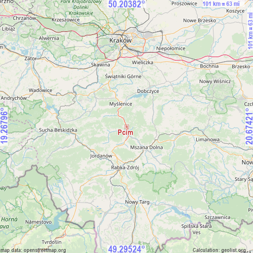
Pcim GPS coordinates[2]
49° 45' 5.976" North, 19° 58' 15.888" East
| Map corner | latitude | longitude |
|---|---|---|
| Upper-left | 50.20382°, | 19.26796° |
| Center: | 49.75166°, | 19.97108° |
| Lower-right: | 49.29524°, | 20.67421° |
| Map W x H: | 101×101 km | = 62.8×62.8mi |
| max Lat: | 54.83135° ⇑93% North |
| Pcim: | 49.75166° |
| min Lat: | ⇓7% South 49.21328° |
| min Long | Pcim | max Long |
| 14.20249° | 19.97108° | 24.03723° |
| W 57.9%⇐ | ⇒42.1% E |
Elevation
Elevation of Pcim is 324 m = 1063 ft, and this is 132.6 m = 435 ft above average elevation for this country.
| Max E: |
974 m = 3196 ft | 10.2% |
| Pcim | 324 m 1063 ft | |
| Avg. | 191.4 m = 628 ft | |
Min E: |
-3 m = -10 ft | 89.8% |
See also: Poland elevation on elevation.city.
Geographical zone
Pcim is located in North temperate zone (between Tropic of Cancer and the Arctic Circle). Distance of this North polar circle is 1869.3 km =1161.5 mi to North.| Distance of | km | miles | from Pcim |
|---|---|---|---|
| North Pole | 4475.2 | 2780.8 | to North |
| Arctic Circle | 1869.3 | 1161.5 | to North |
| Tropic Cancer | 2925.9 | 1818.1 | to South |
| Equator | 5531.9 | 3437.4 | to South |


Nearby cities:
15 places around Pcim: (largest is in red/bold)
• Krzczonów
4.1 km =2.5 mi,  248°
248°
• Lipnik
9.1 km =5.7 mi,  62°
62°
• Lubień
3.6 km =2.2 mi,  171°
171°
• Myślenice
9.4 km =5.8 mi,  345°
345°
• Osieczany
10.1 km =6.3 mi,  4°
4°
• Poręba
6 km =3.7 mi,  33°
33°
• Skomielna Czarna
10.1 km =6.3 mi, 254°
• Stróża
6 km =3.7 mi,  325°
325°
• Tokarnia
7.6 km =4.7 mi, 249°
• Trzebunia
9.9 km =6.2 mi,  296°
296°
• Trzemeśnia
9.2 km =5.7 mi,  23°
23°
• Węglówka
8.5 km =5.3 mi,  103°
103°
• Zasań
9.5 km =5.9 mi,  35°
35°
• Łęki
9.9 km =6.2 mi, 19°
• Łętownia
9.4 km =5.8 mi,  230°
230°
Sources, notices
• [Note1] Compared only with cities in Poland existing in our database
• [Src1] Map data: © OpenStreetMap contributors (CC-BY-SA)
• [Src2] Other city data from geonames.org with taken over terms of usage.
• [Src3] Geographical zone / Annual Mean Temperature by Robert A. Rohde @ Wikipedia
