Łęki geodata
Łęki (Lesser Poland) is a populated place; located in Poland in Europe/Warsaw (GMT+2) time zone. With population of 966 people, there are 2561 cities with bigger population in this country. Compared to other cities in Poland, 90.4% of cities are located further ↑North; 58.5% of cities are located further ←West and 86.1% of cities have lower elevation than Łęki. Note1


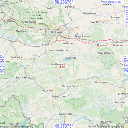
Łęki GPS coordinates[2]
49° 50' 7.368" North, 20° 0' 59.652" East
| Map corner | latitude | longitude |
|---|---|---|
| Upper-left | 50.28676°, | 19.31345° |
| Center: | 49.83538°, | 20.01657° |
| Lower-right: | 49.37975°, | 20.7197° |
| Map W x H: | 100.9×100.8 km | = 62.7×62.6mi |
| max Lat: | 54.83135° ⇑90.4% North |
| Łęki: | 49.83538° |
| min Lat: | ⇓9.6% South 49.21328° |
| min Long | Łęki | max Long |
| 14.20249° | 20.01657° | 24.03723° |
| W 58.5%⇐ | ⇒41.5% E |
Elevation
Elevation of Łęki is 296 m = 971 ft, and this is 104.6 m = 343 ft above average elevation for this country.
| Max E: |
974 m = 3196 ft | 13.9% |
| Łęki | 296 m 971 ft | |
| Avg. | 191.4 m = 628 ft | |
Min E: |
-3 m = -10 ft | 86.1% |
See also: Poland elevation on elevation.city.
Geographical zone
Łęki is located in North temperate zone (between Tropic of Cancer and the Arctic Circle). Distance of this North polar circle is 1860 km =1155.8 mi to North.| Distance of | km | miles | from Łęki |
|---|---|---|---|
| North Pole | 4465.9 | 2775 | to North |
| Arctic Circle | 1860 | 1155.8 | to North |
| Tropic Cancer | 2935.3 | 1823.9 | to South |
| Equator | 5541.2 | 3443.1 | to South |


Nearby cities:
15 places around Łęki: (largest is in red/bold)
• Borzęta
4 km =2.5 mi,  318°
318°
• Brzezowa
3.7 km =2.3 mi,  49°
49°
• Brzączowice
4.6 km =2.9 mi,  18°
18°
• Dobczyce
7.3 km =4.5 mi, 45°
• Kornatka
5.2 km =3.2 mi,  70°
70°
• Krzyszkowice
8.6 km =5.3 mi,  308°
308°
• Lipnik
7.1 km =4.4 mi,  136°
136°
• Myślenice
5.6 km =3.5 mi,  268°
268°
• Osieczany
2.6 km =1.6 mi,  287°
287°
• Polanka
6.3 km =3.9 mi,  297°
297°
• Poręba
4.3 km =2.7 mi,  179°
179°
• Stróża
8 km =5 mi,  236°
236°
• Trzemeśnia
1 km =0.6 mi,  155°
155°
• Wiśniowa
8.8 km =5.5 mi,  126°
126°
• Zasań
2.8 km =1.7 mi, 125°
Sources, notices
• [Note1] Compared only with cities in Poland existing in our database
• [Src1] Map data: © OpenStreetMap contributors (CC-BY-SA)
• [Src2] Other city data from geonames.org with taken over terms of usage.
• [Src3] Geographical zone / Annual Mean Temperature by Robert A. Rohde @ Wikipedia
