Kowalewo Pomorskie geodata
Kowalewo Pomorskie (Kujawsko-Pomorskie) is a populated place; located in Poland in Europe/Warsaw (GMT+2) time zone. With population of 4,081 people, there are 803 cities with bigger population in this country. Compared to other cities in Poland, 85.8% of cities are located further ↓South; 62.1% of cities are located further →East and 83.7% of cities have higher elevation than Kowalewo Pomorskie. Note1
Administrative division(s):
- Level 1: Kujawsko-Pomorskie
- Level 2: Powiat golubsko-dobrzyński
- Level 3: Kowalewo Pomorskie


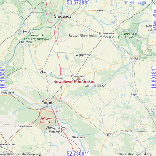
Kowalewo Pomorskie GPS coordinates[2]
53° 9' 15.552" North, 18° 53' 55.248" East
| Map corner | latitude | longitude |
|---|---|---|
| Upper-left | 53.57389°, | 18.19556° |
| Center: | 53.15432°, | 18.89868° |
| Lower-right: | 52.73061°, | 19.60181° |
| Map W x H: | 93.8×93.8 km | = 58.3×58.3mi |
| max Lat: | 54.83135° ⇑14.2% North |
| Kowalewo Pomorskie: | 53.15432° |
| min Lat: | ⇓85.8% South 49.21328° |
| min Long | Kowalewo Pomors | max Long |
| 14.20249° | 18.89868° | 24.03723° |
| W 37.9%⇐ | ⇒62.1% E |
Elevation
Elevation of Kowalewo Pomorskie is 92 m = 302 ft, and this is 99.4 m = 326 ft below average elevation for this country.
| Max E: |
974 m = 3196 ft | 83.7% |
| Avg. | 191.4 m = 628 ft | |
| Kowalewo Pomorskie | 92 m = 302 ft | |
Min E: |
-3 m = -10 ft | 16.3% |
See also: Poland elevation on elevation.city.
Geographical zone
Kowalewo Pomorskie is located in North temperate zone (between Tropic of Cancer and the Arctic Circle). Distance of this North polar circle is 1491 km =926.5 mi to North.| Distance of | km | miles | from Kowalewo Pomorskie |
|---|---|---|---|
| North Pole | 4096.9 | 2545.7 | to North |
| Arctic Circle | 1491 | 926.5 | to North |
| Tropic Cancer | 3304.3 | 2053.2 | to South |
| Equator | 5910.2 | 3672.4 | to South |


Nearby cities:
15 places around Kowalewo Pomorskie: (largest is in red/bold)
• Chełmża
19.9 km =12.4 mi,  279°
279°
• Ciechocin
11.1 km =6.9 mi,  170°
170°
• Dębowa Łąka
17.3 km =10.7 mi,  49°
49°
• Golub-Dobrzyń
11.4 km =7.1 mi,  115°
115°
• Lisewo
11.4 km =7.1 mi,  92°
92°
• Lisewo
21.1 km =13.1 mi,  318°
318°
• Lubicz Dolny
17.1 km =10.6 mi,  216°
216°
• Lubicz Górny
16.5 km =10.3 mi,  211°
211°
• Obrowo
20.4 km =12.7 mi,  183°
183°
• Ostrowite
5.9 km =3.7 mi,  102°
102°
• Płużnica
17.8 km =11.1 mi,  332°
332°
• Radomin
21.1 km =13.1 mi,  110°
110°
• Skąpe
20.1 km =12.5 mi,  290°
290°
• Wąbrzeźno
14.3 km =8.9 mi,  13°
13°
• Łysomice
20.1 km =12.5 mi,  247°
247°
Sources, notices
• [Note1] Compared only with cities in Poland existing in our database
• [Src1] Map data: © OpenStreetMap contributors (CC-BY-SA)
• [Src2] Other city data from geonames.org with taken over terms of usage.
• [Src3] Geographical zone / Annual Mean Temperature by Robert A. Rohde @ Wikipedia
