Osięciny geodata
Osięciny (Kujawsko-Pomorskie) is a seat of a third-order administrative division; located in Poland in Europe/Warsaw (GMT+2) time zone. With population of 2,845 people, there are 1105 cities with bigger population in this country. Compared to other cities in Poland, 78.4% of cities are located further ↓South; 64.7% of cities are located further →East and 83.2% of cities have higher elevation than Osięciny. Note1
Administrative division(s):
- Level 1: Kujawsko-Pomorskie
- Level 2: Powiat radziejowski
- Level 3: Osięciny


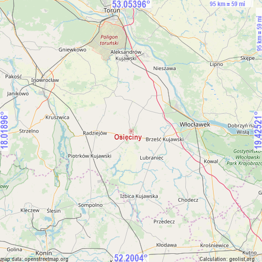
Osięciny GPS coordinates[2]
52° 37' 45.336" North, 18° 43' 19.488" East
| Map corner | latitude | longitude |
|---|---|---|
| Upper-left | 53.05396°, | 18.01896° |
| Center: | 52.62926°, | 18.72208° |
| Lower-right: | 52.2004°, | 19.42521° |
| Map W x H: | 94.9×94.9 km | = 59×59mi |
| max Lat: | 54.83135° ⇑21.6% North |
| Osięciny: | 52.62926° |
| min Lat: | ⇓78.4% South 49.21328° |
| min Long | Osięciny | max Long |
| 14.20249° | 18.72208° | 24.03723° |
| W 35.3%⇐ | ⇒64.7% E |
Elevation
Elevation of Osięciny is 93 m = 305 ft, and this is 98.4 m = 323 ft below average elevation for this country.
| Max E: |
974 m = 3196 ft | 83.2% |
| Avg. | 191.4 m = 628 ft | |
| Osięciny | 93 m = 305 ft | |
Min E: |
-3 m = -10 ft | 16.8% |
See also: Poland elevation on elevation.city.
Geographical zone
Osięciny is located in North temperate zone (between Tropic of Cancer and the Arctic Circle). Distance of this North polar circle is 1549.3 km =962.7 mi to North.| Distance of | km | miles | from Osięciny |
|---|---|---|---|
| North Pole | 4155.2 | 2581.9 | to North |
| Arctic Circle | 1549.3 | 962.7 | to North |
| Tropic Cancer | 3245.9 | 2016.9 | to South |
| Equator | 5851.8 | 3636.1 | to South |


Nearby cities:
15 places around Osięciny: (largest is in red/bold)
• Bobrowniki
23.3 km =14.5 mi,  43°
43°
• Boniewo
21.5 km =13.4 mi,  147°
147°
• Brześć Kujawski
12.4 km =7.7 mi,  102°
102°
• Bytoń
11.7 km =7.3 mi,  227°
227°
• Bądkowo
9.5 km =5.9 mi,  27°
27°
• Dobre
11.5 km =7.1 mi,  301°
301°
• Dąbrowa Biskupia
20.5 km =12.7 mi,  324°
324°
• Koneck
17.1 km =10.6 mi,  359°
359°
• Lubanie
18.7 km =11.6 mi,  45°
45°
• Lubraniec
12.3 km =7.6 mi,  142°
142°
• Piotrków Kujawski
17.4 km =10.8 mi,  240°
240°
• Radziejów
13.1 km =8.1 mi,  267°
267°
• Topólka
14 km =8.7 mi,  182°
182°
• Waganiec
21.7 km =13.5 mi, 28°
• Zakrzewo
15.7 km =9.8 mi,  337°
337°
Sources, notices
• [Note1] Compared only with cities in Poland existing in our database
• [Src1] Map data: © OpenStreetMap contributors (CC-BY-SA)
• [Src2] Other city data from geonames.org with taken over terms of usage.
• [Src3] Geographical zone / Annual Mean Temperature by Robert A. Rohde @ Wikipedia
