Dobre geodata
Dobre (Kujawsko-Pomorskie) is a seat of a third-order administrative division; located in Poland in Europe/Warsaw (GMT+2) time zone. With population of 2,500 people, there are 1240 cities with bigger population in this country. Compared to other cities in Poland, 79.1% of cities are located further ↓South; 67% of cities are located further →East and 85.7% of cities have higher elevation than Dobre. Note1


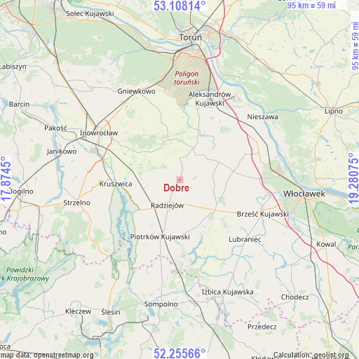
Dobre GPS coordinates[2]
52° 41' 2.328" North, 18° 34' 39.432" East
| Map corner | latitude | longitude |
|---|---|---|
| Upper-left | 53.10814°, | 17.8745° |
| Center: | 52.68398°, | 18.57762° |
| Lower-right: | 52.25566°, | 19.28075° |
| Map W x H: | 94.8×94.8 km | = 58.9×58.9mi |
| max Lat: | 54.83135° ⇑20.9% North |
| Dobre: | 52.68398° |
| min Lat: | ⇓79.1% South 49.21328° |
| min Long | Dobre | max Long |
| 14.20249° | 18.57762° | 24.03723° |
| W 33%⇐ | ⇒67% E |
Elevation
Elevation of Dobre is 88 m = 289 ft, and this is 103.4 m = 339 ft below average elevation for this country.
| Max E: |
974 m = 3196 ft | 85.7% |
| Avg. | 191.4 m = 628 ft | |
| Dobre | 88 m = 289 ft | |
Min E: |
-3 m = -10 ft | 14.3% |
See also: Poland elevation on elevation.city.
Geographical zone
Dobre is located in North temperate zone (between Tropic of Cancer and the Arctic Circle). Distance of this North polar circle is 1543.3 km =959 mi to North.| Distance of | km | miles | from Dobre |
|---|---|---|---|
| North Pole | 4149.2 | 2578.2 | to North |
| Arctic Circle | 1543.3 | 959 | to North |
| Tropic Cancer | 3252 | 2020.7 | to South |
| Equator | 5857.9 | 3639.9 | to South |


Nearby cities:
15 places around Dobre: (largest is in red/bold)
• Aleksandrów Kujawski
22.8 km =14.2 mi,  19°
19°
• Brześć Kujawski
23.6 km =14.7 mi,  111°
111°
• Bytoń
14.1 km =8.8 mi,  175°
175°
• Bądkowo
14.3 km =8.9 mi,  80°
80°
• Dąbrowa Biskupia
10.8 km =6.7 mi,  347°
347°
• Koneck
14.6 km =9.1 mi,  40°
40°
• Kruszwica
16.6 km =10.3 mi,  266°
266°
• Lubanie
24.1 km =15 mi,  73°
73°
• Lubraniec
23.4 km =14.5 mi,  132°
132°
• Osięciny
11.5 km =7.1 mi,  121°
121°
• Piotrków Kujawski
15.7 km =9.8 mi,  199°
199°
• Radziejów
7.4 km =4.6 mi,  207°
207°
• Topólka
22.1 km =13.7 mi,  155°
155°
• Waganiec
23.9 km =14.9 mi,  57°
57°
• Zakrzewo
9.1 km =5.7 mi, 23°
Sources, notices
• [Note1] Compared only with cities in Poland existing in our database
• [Src1] Map data: © OpenStreetMap contributors (CC-BY-SA)
• [Src2] Other city data from geonames.org with taken over terms of usage.
• [Src3] Geographical zone / Annual Mean Temperature by Robert A. Rohde @ Wikipedia
