Lubraniec geodata
Lubraniec (Kujawsko-Pomorskie) is a seat of a third-order administrative division; located in Poland in Europe/Warsaw (GMT+2) time zone. With population of 3,344 people, there are 957 cities with bigger population in this country. Compared to other cities in Poland, 77% of cities are located further ↓South; 62.8% of cities are located further →East and 88.1% of cities have higher elevation than Lubraniec. Note1
Administrative division(s):
- Level 1: Kujawsko-Pomorskie
- Level 2: Powiat włocławski
- Level 3: Lubraniec


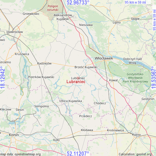
Lubraniec GPS coordinates[2]
52° 32' 30.408" North, 18° 49' 57.144" East
| Map corner | latitude | longitude |
|---|---|---|
| Upper-left | 52.96733°, | 18.12942° |
| Center: | 52.54178°, | 18.83254° |
| Lower-right: | 52.11207°, | 19.53567° |
| Map W x H: | 95.1×95.1 km | = 59.1×59.1mi |
| max Lat: | 54.83135° ⇑23% North |
| Lubraniec: | 52.54178° |
| min Lat: | ⇓77% South 49.21328° |
| min Long | Lubraniec | max Long |
| 14.20249° | 18.83254° | 24.03723° |
| W 37.2%⇐ | ⇒62.8% E |
Elevation
Elevation of Lubraniec is 81 m = 266 ft, and this is 110.4 m = 362 ft below average elevation for this country.
| Max E: |
974 m = 3196 ft | 88.1% |
| Avg. | 191.4 m = 628 ft | |
| Lubraniec | 81 m = 266 ft | |
Min E: |
-3 m = -10 ft | 11.9% |
See also: Poland elevation on elevation.city.
Geographical zone
Lubraniec is located in North temperate zone (between Tropic of Cancer and the Arctic Circle). Distance of this North polar circle is 1559.1 km =968.8 mi to North.| Distance of | km | miles | from Lubraniec |
|---|---|---|---|
| North Pole | 4165 | 2588 | to North |
| Arctic Circle | 1559.1 | 968.8 | to North |
| Tropic Cancer | 3236.2 | 2010.9 | to South |
| Equator | 5842.1 | 3630.1 | to South |


Nearby cities:
15 places around Lubraniec: (largest is in red/bold)
• Boniewo
9.4 km =5.8 mi,  154°
154°
• Brdów
22 km =13.7 mi,  198°
198°
• Brześć Kujawski
8.5 km =5.3 mi,  33°
33°
• Bytoń
16.1 km =10 mi,  276°
276°
• Bądkowo
18.4 km =11.4 mi,  350°
350°
• Choceń
13.7 km =8.5 mi,  116°
116°
• Chodecz
20.1 km =12.5 mi,  138°
138°
• Czerniewice
17.5 km =10.9 mi,  101°
101°
• Izbica Kujawska
14.3 km =8.9 mi, 199°
• Kowal
21.4 km =13.3 mi,  93°
93°
• Osięciny
12.3 km =7.6 mi,  322°
322°
• Piotrków Kujawski
22.6 km =14 mi,  272°
272°
• Radziejów
22.6 km =14 mi,  294°
294°
• Topólka
9.2 km =5.7 mi,  242°
242°
• Włocławek
19.8 km =12.3 mi,  53°
53°
Sources, notices
• [Note1] Compared only with cities in Poland existing in our database
• [Src1] Map data: © OpenStreetMap contributors (CC-BY-SA)
• [Src2] Other city data from geonames.org with taken over terms of usage.
• [Src3] Geographical zone / Annual Mean Temperature by Robert A. Rohde @ Wikipedia
