Topólka geodata
Topólka (Kujawsko-Pomorskie) is a seat of a third-order administrative division; located in Poland in Europe/Warsaw (GMT+2) time zone. With population of 449 people, there are 3567 cities with bigger population in this country. Compared to other cities in Poland, 76.5% of cities are located further ↓South; 64.9% of cities are located further →East and 86.3% of cities have higher elevation than Topólka. Note1
Administrative division(s):
- Level 1: Kujawsko-Pomorskie
- Level 2: Powiat radziejowski
- Level 3: Topólka


Topólka GPS coordinates[2]
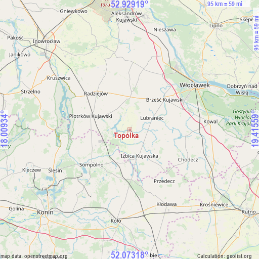
52° 30' 11.772" North, 18° 42' 44.856" East
| Map corner | latitude | longitude |
|---|---|---|
| Upper-left | 52.92919°, | 18.00934° |
| Center: | 52.50327°, | 18.71246° |
| Lower-right: | 52.07318°, | 19.41559° |
| Map W x H: | 95.2×95.2 km | = 59.2×59.2mi |
| max Lat: | 54.83135° ⇑23.5% North |
| Topólka: | 52.50327° |
| min Lat: | ⇓76.5% South 49.21328° |
| min Long | Topólka | max Long |
| 14.20249° | 18.71246° | 24.03723° |
| W 35.1%⇐ | ⇒64.9% E |
Elevation
Elevation of Topólka is 86 m = 282 ft, and this is 105.4 m = 346 ft below average elevation for this country.
| Max E: |
974 m = 3196 ft | 86.3% |
| Avg. | 191.4 m = 628 ft | |
| Topólka | 86 m = 282 ft | |
Min E: |
-3 m = -10 ft | 13.7% |
See also: Poland elevation on elevation.city.
Geographical zone
Topólka is located in North temperate zone (between Tropic of Cancer and the Arctic Circle). Distance of this North polar circle is 1563.4 km =971.5 mi to North.| Distance of | km | miles | from Topólka |
|---|---|---|---|
| North Pole | 4169.2 | 2590.6 | to North |
| Arctic Circle | 1563.4 | 971.5 | to North |
| Tropic Cancer | 3231.9 | 2008.2 | to South |
| Equator | 5837.8 | 3627.4 | to South |


Nearby cities:
15 places around Topólka: (largest is in red/bold)
• Babiak
17.8 km =11.1 mi,  190°
190°
• Boniewo
12.8 km =8 mi,  109°
109°
• Brdów
16.6 km =10.3 mi,  175°
175°
• Brześć Kujawski
17.1 km =10.6 mi,  48°
48°
• Bytoń
10 km =6.2 mi,  307°
307°
• Choceń
20.5 km =12.7 mi,  95°
95°
• Dobre
22.1 km =13.7 mi,  335°
335°
• Izbica Kujawska
9.8 km =6.1 mi,  159°
159°
• Lubraniec
9.2 km =5.7 mi,  62°
62°
• Osięciny
14 km =8.7 mi,  2°
2°
• Piotrków Kujawski
15.4 km =9.6 mi,  290°
290°
• Police
22.5 km =14 mi,  226°
226°
• Radziejów
18.4 km =11.4 mi,  317°
317°
• Sompolno
19.1 km =11.9 mi, 228°
• Wierzbinek
15.3 km =9.5 mi,  242°
242°
Sources, notices
• [Note1] Compared only with cities in Poland existing in our database
• [Src1] Map data: © OpenStreetMap contributors (CC-BY-SA)
• [Src2] Other city data from geonames.org with taken over terms of usage.
• [Src3] Geographical zone / Annual Mean Temperature by Robert A. Rohde @ Wikipedia
