Przystajń geodata
Przystajń (Silesia) is a populated place; located in Poland in Europe/Warsaw (GMT+2) time zone. With population of 2,283 people, there are 1331 cities with bigger population in this country. Compared to other cities in Poland, 58.2% of cities are located further ↑North; 65.2% of cities are located further →East and 77.2% of cities have lower elevation than Przystajń. Note1


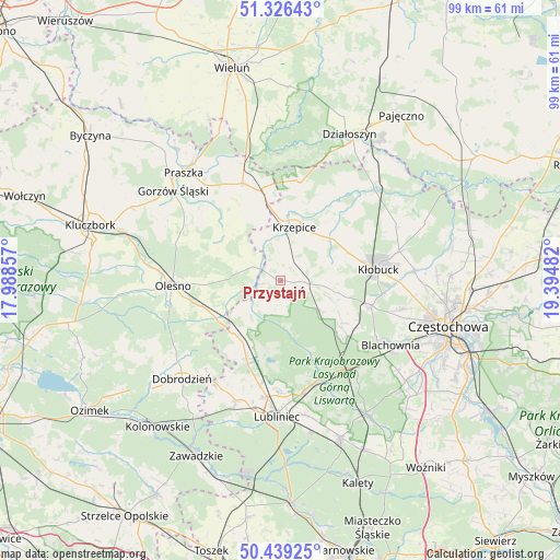
Przystajń GPS coordinates[2]
50° 53' 5.82" North, 18° 41' 30.084" East
| Map corner | latitude | longitude |
|---|---|---|
| Upper-left | 51.32643°, | 17.98857° |
| Center: | 50.88495°, | 18.69169° |
| Lower-right: | 50.43925°, | 19.39482° |
| Map W x H: | 98.6×98.6 km | = 61.3×61.3mi |
| max Lat: | 54.83135° ⇑58.2% North |
| Przystajń: | 50.88495° |
| min Lat: | ⇓41.8% South 49.21328° |
| min Long | Przystajń | max Long |
| 14.20249° | 18.69169° | 24.03723° |
| W 34.8%⇐ | ⇒65.2% E |
Elevation
Elevation of Przystajń is 255 m = 837 ft, and this is 63.6 m = 209 ft above average elevation for this country.
| Max E: |
974 m = 3196 ft | 22.8% |
| Przystajń | 255 m 837 ft | |
| Avg. | 191.4 m = 628 ft | |
Min E: |
-3 m = -10 ft | 77.2% |
See also: Poland elevation on elevation.city.
Geographical zone
Przystajń is located in North temperate zone (between Tropic of Cancer and the Arctic Circle). Distance of this North polar circle is 1743.3 km =1083.2 mi to North.| Distance of | km | miles | from Przystajń |
|---|---|---|---|
| North Pole | 4349.2 | 2702.5 | to North |
| Arctic Circle | 1743.3 | 1083.2 | to North |
| Tropic Cancer | 3052 | 1896.4 | to South |
| Equator | 5657.9 | 3515.7 | to South |


Nearby cities:
15 places around Przystajń: (largest is in red/bold)
• Ciasna
15.7 km =9.8 mi,  201°
201°
• Herby
20.1 km =12.5 mi,  136°
136°
• Kochanowice
20.4 km =12.7 mi,  168°
168°
• Krzepice
9.9 km =6.2 mi,  15°
15°
• Kłobuck
17.3 km =10.7 mi,  84°
84°
• Lipie
16 km =9.9 mi,  27°
27°
• Olesno
19 km =11.8 mi,  267°
267°
• Opatów
11.9 km =7.4 mi,  48°
48°
• Panki
4.2 km =2.6 mi,  92°
92°
• Radłow
12.2 km =7.6 mi,  296°
296°
• Rudniki
18.3 km =11.4 mi,  339°
339°
• Sieraków Śląski
12.2 km =7.6 mi,  221°
221°
• Starokrzepice
7.6 km =4.7 mi, 339°
• Truskolasy
9.7 km =6 mi,  101°
101°
• Wręczyca Wielka
16.7 km =10.4 mi,  105°
105°
Sources, notices
• [Note1] Compared only with cities in Poland existing in our database
• [Src1] Map data: © OpenStreetMap contributors (CC-BY-SA)
• [Src2] Other city data from geonames.org with taken over terms of usage.
• [Src3] Geographical zone / Annual Mean Temperature by Robert A. Rohde @ Wikipedia
