Brzeg geodata
Brzeg (Opole Voivodeship) is a seat of a second-order administrative division; located in Poland in Europe/Warsaw (GMT+2) time zone. With population of 38,259 people, there are 137 cities with bigger population in this country. Compared to other cities in Poland, 58.8% of cities are located further ↑North; 80.3% of cities are located further →East and 59.9% of cities have higher elevation than Brzeg. Note1


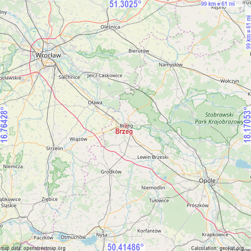
Brzeg GPS coordinates[2]
50° 51' 38.844" North, 17° 28' 2.64" East
| Map corner | latitude | longitude |
|---|---|---|
| Upper-left | 51.3025°, | 16.76428° |
| Center: | 50.86079°, | 17.4674° |
| Lower-right: | 50.41486°, | 18.17053° |
| Map W x H: | 98.7×98.7 km | = 61.3×61.3mi |
| max Lat: | 54.83135° ⇑58.8% North |
| Brzeg: | 50.86079° |
| min Lat: | ⇓41.2% South 49.21328° |
| min Long | Brzeg | max Long |
| 14.20249° | 17.4674° | 24.03723° |
| W 19.7%⇐ | ⇒80.3% E |
Elevation
Elevation of Brzeg is 147 m = 482 ft, and this is 44.4 m = 146 ft below average elevation for this country.
| Max E: |
974 m = 3196 ft | 59.9% |
| Avg. | 191.4 m = 628 ft | |
| Brzeg | 147 m = 482 ft | |
Min E: |
-3 m = -10 ft | 40.1% |
See also: Poland elevation on elevation.city.
Geographical zone
Brzeg is located in North temperate zone (between Tropic of Cancer and the Arctic Circle). Distance of this North polar circle is 1746 km =1084.9 mi to North.| Distance of | km | miles | from Brzeg |
|---|---|---|---|
| North Pole | 4351.9 | 2704.1 | to North |
| Arctic Circle | 1746 | 1084.9 | to North |
| Tropic Cancer | 3049.3 | 1894.7 | to South |
| Equator | 5655.2 | 3514 | to South |


Nearby cities:
15 places around Brzeg: (largest is in red/bold)
• Bystrzyca
12.1 km =7.5 mi,  336°
336°
• Grodków
19 km =11.8 mi,  197°
197°
• Krzyżowice
5.9 km =3.7 mi,  182°
182°
• Lewin Brzeski
16.3 km =10.1 mi,  139°
139°
• Lubsza
7.2 km =4.5 mi,  31°
31°
• Michałow
13.3 km =8.3 mi,  167°
167°
• Minkowice Oławskie
17.6 km =10.9 mi,  358°
358°
• Olszanka
7.3 km =4.5 mi, 173°
• Osiek
12.6 km =7.8 mi,  283°
283°
• Oława
15.5 km =9.6 mi,  307°
307°
• Pogorzela
8.4 km =5.2 mi, 167°
• Skarbimierz Osiedle
3.8 km =2.4 mi,  244°
244°
• Skorogoszcz
18.8 km =11.7 mi,  126°
126°
• Wiązów
19.3 km =12 mi,  254°
254°
• Łosiów
10.4 km =6.5 mi, 138°
Sources, notices
• [Note1] Compared only with cities in Poland existing in our database
• [Src1] Map data: © OpenStreetMap contributors (CC-BY-SA)
• [Src2] Other city data from geonames.org with taken over terms of usage.
• [Src3] Geographical zone / Annual Mean Temperature by Robert A. Rohde @ Wikipedia
