Domaniów geodata
Domaniów (Lower Silesia) is a populated place; located in Poland in Europe/Warsaw (GMT+2) time zone. With population of 759 people, there are 2937 cities with bigger population in this country. Compared to other cities in Poland, 57.9% of cities are located further ↑North; 82.9% of cities are located further →East and 60.3% of cities have higher elevation than Domaniów. Note1


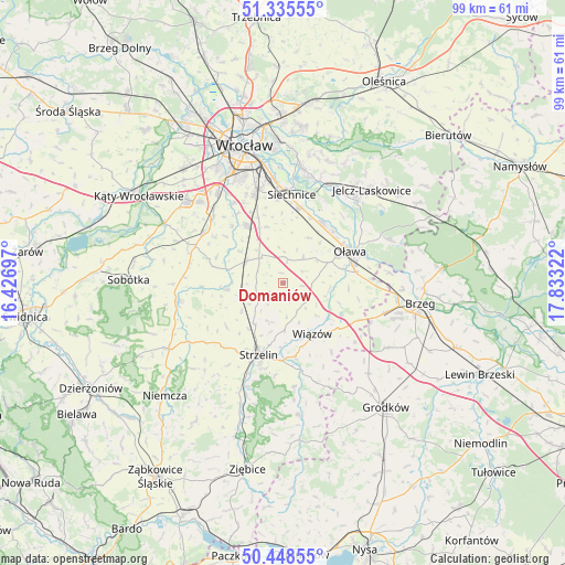
Domaniów GPS coordinates[2]
50° 53' 38.976" North, 17° 7' 48.324" East
| Map corner | latitude | longitude |
|---|---|---|
| Upper-left | 51.33555°, | 16.42697° |
| Center: | 50.89416°, | 17.13009° |
| Lower-right: | 50.44855°, | 17.83322° |
| Map W x H: | 98.6×98.6 km | = 61.3×61.3mi |
| max Lat: | 54.83135° ⇑57.9% North |
| Domaniów: | 50.89416° |
| min Lat: | ⇓42.1% South 49.21328° |
| min Long | Domaniów | max Long |
| 14.20249° | 17.13009° | 24.03723° |
| W 17.1%⇐ | ⇒82.9% E |
Elevation
Elevation of Domaniów is 146 m = 479 ft, and this is 45.4 m = 149 ft below average elevation for this country.
| Max E: |
974 m = 3196 ft | 60.3% |
| Avg. | 191.4 m = 628 ft | |
| Domaniów | 146 m = 479 ft | |
Min E: |
-3 m = -10 ft | 39.7% |
See also: Poland elevation on elevation.city.
Geographical zone
Domaniów is located in North temperate zone (between Tropic of Cancer and the Arctic Circle). Distance of this North polar circle is 1742.3 km =1082.6 mi to North.| Distance of | km | miles | from Domaniów |
|---|---|---|---|
| North Pole | 4348.2 | 2701.8 | to North |
| Arctic Circle | 1742.3 | 1082.6 | to North |
| Tropic Cancer | 3053 | 1897 | to South |
| Equator | 5658.9 | 3516.3 | to South |


Nearby cities:
15 places around Domaniów: (largest is in red/bold)
• Borów
9.8 km =6.1 mi,  262°
262°
• Domasław
17.8 km =11.1 mi,  316°
316°
• Kobierzyce
16.1 km =10 mi,  301°
301°
• Osiek
11.4 km =7.1 mi,  93°
93°
• Oława
12.8 km =8 mi,  62°
62°
• Radwanice
17.8 km =11.1 mi,  355°
355°
• Ratowice
18.4 km =11.4 mi,  32°
32°
• Siechnice
15.6 km =9.7 mi,  4°
4°
• Strzelin
13.3 km =8.3 mi,  200°
200°
• Wierzbno
5.9 km =3.7 mi,  36°
36°
• Wiązów
10.2 km =6.3 mi,  150°
150°
• Węgry
7.4 km =4.6 mi, 301°
• Święta Katarzyna
14.7 km =9.1 mi, 355°
• Żerniki Wrocławskie
16.3 km =10.1 mi,  341°
341°
• Żórawina
11.6 km =7.2 mi,  325°
325°
Sources, notices
• [Note1] Compared only with cities in Poland existing in our database
• [Src1] Map data: © OpenStreetMap contributors (CC-BY-SA)
• [Src2] Other city data from geonames.org with taken over terms of usage.
• [Src3] Geographical zone / Annual Mean Temperature by Robert A. Rohde @ Wikipedia
