Nowa Wieś Lęborska geodata
Nowa Wieś Lęborska (Pomerania) is a populated place; located in Poland in Europe/Warsaw (GMT+2) time zone. With population of 2,188 people, there are 1375 cities with bigger population in this country. Compared to other cities in Poland, 98.9% of cities are located further ↓South; 77.9% of cities are located further →East and 97.5% of cities have higher elevation than Nowa Wieś Lęborska. Note1


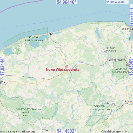
Nowa Wieś Lęborska GPS coordinates[2]
54° 33' 31.608" North, 17° 43' 39.216" East
| Map corner | latitude | longitude |
|---|---|---|
| Upper-left | 54.96446°, | 17.02444° |
| Center: | 54.55878°, | 17.72756° |
| Lower-right: | 54.14902°, | 18.43069° |
| Map W x H: | 90.7×90.7 km | = 56.4×56.4mi |
| max Lat: | 54.83135° ⇑1.1% North |
| Nowa Wieś Lęborska: | 54.55878° |
| min Lat: | ⇓98.9% South 49.21328° |
| min Long | Nowa Wieś Lęb | max Long |
| 14.20249° | 17.72756° | 24.03723° |
| W 22.1%⇐ | ⇒77.9% E |
Elevation
Elevation of Nowa Wieś Lęborska is 18 m = 59 ft, and this is 173.4 m = 569 ft below average elevation for this country.
| Max E: |
974 m = 3196 ft | 97.5% |
| Avg. | 191.4 m = 628 ft | |
| Nowa Wieś Lęborska | 18 m = 59 ft | |
Min E: |
-3 m = -10 ft | 2.5% |
See also: Poland elevation on elevation.city.
Geographical zone
Nowa Wieś Lęborska is located in North temperate zone (between Tropic of Cancer and the Arctic Circle). Distance of this North polar circle is 1334.8 km =829.4 mi to North.| Distance of | km | miles | from Nowa Wieś Lęborska |
|---|---|---|---|
| North Pole | 3940.7 | 2448.6 | to North |
| Arctic Circle | 1334.8 | 829.4 | to North |
| Tropic Cancer | 3460.4 | 2150.2 | to South |
| Equator | 6066.4 | 3769.5 | to South |


Nearby cities:
15 places around Nowa Wieś Lęborska: (largest is in red/bold)
• Bobrowniki
25.5 km =15.8 mi,  261°
261°
• Cewice
13.7 km =8.5 mi,  178°
178°
• Choczewo
22.7 km =14.1 mi,  27°
27°
• Czarna Dąbrówka
24.9 km =15.5 mi,  205°
205°
• Gniewino
25.6 km =15.9 mi,  46°
46°
• Główczyce
23.9 km =14.9 mi,  286°
286°
• Linia
17.9 km =11.1 mi,  131°
131°
• Luzino
24.6 km =15.3 mi,  88°
88°
• Lębork
2.6 km =1.6 mi,  146°
146°
• Maszewo Lęborskie
9.8 km =6.1 mi, 176°
• Potęgowo
17.7 km =11 mi,  241°
241°
• Wicko
14.3 km =8.9 mi,  330°
330°
• Łeba
25.1 km =15.6 mi, 333°
• Łupawa
25.5 km =15.8 mi,  232°
232°
• Łęczyce
9.4 km =5.8 mi,  65°
65°
Sources, notices
• [Note1] Compared only with cities in Poland existing in our database
• [Src1] Map data: © OpenStreetMap contributors (CC-BY-SA)
• [Src2] Other city data from geonames.org with taken over terms of usage.
• [Src3] Geographical zone / Annual Mean Temperature by Robert A. Rohde @ Wikipedia
